This copy is copyright protected.
Copyright © 2024 Geographicus Rare Antique Maps
1784 Cook Map of the American Pacific Northwest (Alaska) and Northeast Asia
AlaskaAsia-cook-1784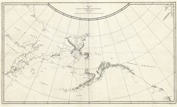

The north-west coast of North America was sighted on 7 March and for the next six and a half months Cook carried out a running survey of some 4000 miles of its coast from Cape Blanco on the coast of Oregon to Icy Cape on the north coast of Alaska, where he was forced to turn back by an impenetrable wall of ice. A search for a route back to Europe north of Siberia also proved fruitless. During this cruise Cook became the first European to enter Nootka Sound on the north-west coast of Vancouver Island, where he remained for a month taking astronomical observations and cutting spars for use as spare masts and yardarms. Trade was carried out with the native Mowachaht for furs, mostly of the sea otter, which when sold later in China drew attention to the commercial potential of this trade.Cook's discoveries on this, his third voyage to the Pacific, finally put to rest confused notations of a Sea of the West as well as hopes for the discovery of a Arctic northwest passage.
Captain James Cook (7 November 1728 - 14 February 1779) is a seminal figure in the history of cartography for which we can offer only a cursory treatment here. Cook began sailing as a teenager in the British Merchant Navy before joining the Royal Navy in 1755. He was posted in America for a time where he worked Samuel Holland, William Bligh, and others in the mapping of the St. Lawrence River and Newfoundland. In 1766 Cook was commissioned to explore the Pacific and given a Captaincy with command of the Endeavour. What followed were three historic voyages of discovery, the highlights of which include the first European contact with eastern Australia, the discovery of the Hawaiian Islands (among many other Polynesian groups), the first circumnavigation of New Zealand, some of the first sightings of Antarctica, the first accurate mapping of the Pacific Northwest, and ultimately his own untimely death at the hands of angry Hawaiians in 1779. The influence of Cook work on the mapping and exploration of the Pacific cannot be understated. More by this mapmaker...
Copyright © 2024 Geographicus Rare Antique Maps | Geographicus Rare Antique Maps
This copy is copyright protected.
Copyright © 2024 Geographicus Rare Antique Maps