This copy is copyright protected.
Copyright © 2024 Geographicus Rare Antique Maps
1742 Hederichs Map of America (North America, South America), insular California
Americae-hederich-1742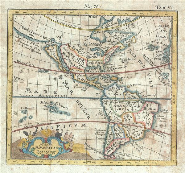

Know, that on the right hand of the Indies there is an island called California very close to the side of the Terrestrial Paradise; and it is peopled by black women, without any man among them, for they live in the manner of Amazons.Baja California was subsequently discovered in 1533 by Fortun Ximenez, who had been sent to the area by Hernan Cortez. When Cortez himself traveled to Baja, he must have had Montalvo's novel in mind, for he immediately claimed the 'Island of California' for the Spanish King. By the late 16th and early 17th century ample evidence had been amassed, through explorations of the region by Francisco de Ulloa, Hernando de Alarcon and others, that California was in fact a peninsula. However, by this time other factors were in play. Francis Drake had sailed north and claimed 'New Albion' (identified here on the northwest coast of California Island) near modern day Washington or Vancouver for England. The Spanish thus needed to promote Cortez's claim on the 'Island of California' to preempt English claims on the western coast of North America. The significant influence of the Spanish crown on European cartographers caused a major resurgence of the Insular California theory. Just before this map was made Eusebio Kino, a Jesuit missionary, traveled overland from Mexico to California, proving conclusively the peninsularity of California. This is also one of the last maps to represent California as an Island.
Benjamin Hederichs (December 12, 1675 - July 18, 1748) was a German historian and editor. He was born in Geithain and studied at the Besuch der Fürstenschule Grimma and afterwards pursued further studies in Leipzig and Wittenberg. In 172 he worked as a monastic teacher and later rector in Großenhain. Hederich produced numerous dictionaries and textbooks and contributed studies to others in chronology, genealogy, heraldry, numismatics, and diplomacy. More by this mapmaker...
Copyright © 2024 Geographicus Rare Antique Maps | Geographicus Rare Antique Maps
This copy is copyright protected.
Copyright © 2024 Geographicus Rare Antique Maps