This copy is copyright protected.
Copyright © 2024 Geographicus Rare Antique Maps
1918 Bernard Sleigh 'Anciente Mappe of Fairlyand'
AncientMappeofFariyland2-sleigh-1918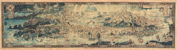

In the Heart of every child, is hidden away a little golden key which unlocks the door …As pointed out by map historian Tim Bryars, this map was printed in 1918, the final year of World War I. Bryars astutely asks,
many boats waiting always to take their willing travelers to the distant gates of Ivory. Some there be who venture forth into a new world, breathing fearlessly its unaccustomed air; enter some dainty, carven shallop and set forth to those rainbow-guarded shores …
stout is the heart that faces these dangers, daring the soul that braes these troubled seas, to enter at last the hidden entrance to the Harbour of Dreamland...
Could the map constitute a yearning for a return to pre-1914 Edwardian innocence? Compared with the devastated, bomb-blasted landscape of northern France, this vision of a make-believe land may have seemed a seductive escape for a European society bearing the psychological and physical scars of mass conflict.Another approach to this map is to study it within the context of the Arts and Crafts Movement. Sleigh was a close associate of Robert Morris and this map clearly follows Arts and Crafts Movement ideology. The typeface and decoration are very much in the style of Morris's Kelmscott Press and its embrace of tradition pre-industrial ear production techniques.
Bernard Sleigh (1852 - 1954) was a British author, muralist, stained-glass artist, illustrator and wood engraver active in London in the late 18th and early 19th centuries. Sleigh was born in Birmingham, England and studied at the Birmingham School of art. He was a student of Arthur Gaskin. His work is deeply influenced by his early association with William Morris and the Arts and Crafts Movement. He was a member of the Royal Birmingham Society of Artists between 1923 and 1928. His most famous cartographic work is An Ancient Mappe of Fairyland, Newly Discovered and Set Forth, published at the end of the Great War or World War I. He also published several less well known maps of Birmingham and other parts of England. Sleigh retired to Chipping Campden in 1937. For those who are unacquainted with 'Chipping Campden' or 'Chippy,' in the heart of England's picturesque Cotswolds, it is a place that seems more akin to 'Fairy Land' than to the modern industrial world. More by this mapmaker...
Copyright © 2024 Geographicus Rare Antique Maps | Geographicus Rare Antique Maps
This copy is copyright protected.
Copyright © 2024 Geographicus Rare Antique Maps