Title
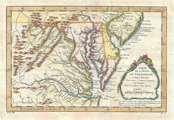
Carte de la Baye de Chesapeack et Pays Voisins.
1757 (undated)
8.5 x 11.5 in (21.59 x 29.21 cm)
1 : 2300000
Description
Attributed to the French cartographer Jacques-Nicholas Bellin, this is a beautiful 1757 first state first edition map of the Chesapeake Bay including Virginia, Maryland, Delaware and parts of New Jersey and Pennsylvania. Bellin's map covers from Cape Henry north to the Susquehanna River and Burlington, New Jersey and inland as far as the Appalachian Mountains. The Chesapeake Bay is shown in full, as are many of its river estuaries. The map notably includes the Chesapeake Bay's western watershed, luring potential colonists with the promise of large navigable rivers and rich fertile lands.
In the title cartouche Bellin cites that this map is derived from the 'best English maps' (Turee des Meilleures Cartes Angloises). In this he can only be referring to the Fry-Jefferson map of 1753. Such is apparent from the cartographer's inclusion of Moulin Hoggats (Hoggett's Mill) on the upper Appomattox River. This mill first appeared on the Fry-Jefferson map and did not subsequently reappear on another published map until the present issue.
Bellin prepared this map for issue in the 1757 French edition of Provost's Histoire des Voyages. The present example is the first edition, identifiable by the right hand pointing to a note just below the title cartouche. There were five editions subsequent editions of this map as well as several variant states.
Cartographer
Jacques-Nicolas Bellin (1703 - March 21, 1772) was one of the most important cartographers of the 18th century. With a career spanning some 50 years, Bellin is best understood as geographe de cabinet and transitional mapmaker spanning the gap between 18th and early-19th century cartographic styles. His long career as Hydrographer and Ingénieur Hydrographe at the French Dépôt des cartes et plans de la Marine resulted in hundreds of high quality nautical charts of practically everywhere in the world. A true child of the Enlightenment Era, Bellin's work focuses on function and accuracy tending in the process to be less decorative than the earlier 17th and 18th century cartographic work. Unlike many of his contemporaries, Bellin was always careful to cite his references and his scholarly corpus consists of over 1400 articles on geography prepared for Diderot's Encyclopedie. Bellin, despite his extraordinary success, may not have enjoyed his work, which is described as "long, unpleasant, and hard." In addition to numerous maps and charts published during his lifetime, many of Bellin's maps were updated (or not) and published posthumously. He was succeeded as Ingénieur Hydrographe by his student, also a prolific and influential cartographer, Rigobert Bonne. More by this mapmaker...
Source
Provost, A., L'Histoire Generale des Voyages, Vol XIV, plate 8.
Condition
Very good. Minor wear along original fold lines. Minor toning and offsetting, with some foxing at places. Original platemark visible.
References
Library of Congress, Map Division, G3792.C5 1757.B4. Tooley, R.V., 'Printed Maps of America Part IV', in Map Collectors' Series # 96, 113-114, Map nos. 873 And 875. Cumming, William P., The Southeast in Early Maps, 228. Phillips, Philip Lee, Virginia Cartography, 1896, 50, 51, 52. Mathews, Edward B., 'Bibliography and Cartography of Maryland', in Maryland Geological Survey, Vol. 1, Part IV, 348. Sellers, John R. and Van Ee, Patricia, Maps and Charts of North America and the West Indies 1750-1789, nos. 1383, 1437. Sabin, Joseph, A Dictionary of Books Relating to America from its Discovery to the Present Time, # 65402, # 65403. Wooldridge, W., Mapping Virginia from the Age of Exploration to the Civil War, no 105.