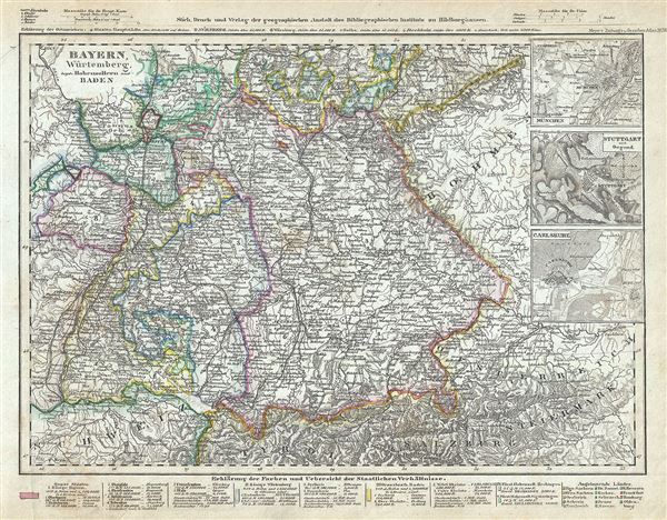
This is a beautiful map of southern Germany including Bavaria, Wurttemberg and Baden by Joseph Meyer. It covers Germany from Gotha south past the River Main (Mayne or Maine) as far as the Hornberg, depicting the semi-autonomous kingdoms, duchies and Prussian territories of southern Germany. These include Bavaria, Baden, Hohenzollern and Wurttemberg (Wirtemberg). Towns, rivers, mountains, railroads, and various other important topographical details are noted. Elevation throughout is rendered by hachure and political and territorial boundaries are outlined in color.
With the abolition of the Holy Roman Empire in 1806, Bavaria became the Kingdom of Bavaria. Its territories were doubled and it became the second largest Kingdom after the Kingdom of Prussia. The Congress of Vienna in 1815 created The German Confederation to coordinate the economies of these separate but culturally related German-speaking countries. The Confederation acted as a buffer zone between Austria and Prussia, the two largest and most powerful member states. It briefly dissolved during the Revolution of 1948, but was re-established in 1850. Nonetheless the rivalry between the two powerful states increased until it finally broke out into the Austro-Prussian War. Prussia won the Austro-Prussian War in 1866 which ultimately led to the collapse of the German Confederation. A few years later, in 1871, most of the former Confederation states were folded into the newly proclaimed German Empire.
This map was issued as plate no. 30 in Meyer's Zeitung Atlas. Although all the maps in this atlas are not individually dated, the title page and maps were often updated while the imprint with the date was not, causing confusion to the exact date for some of the maps. Moreover some maps in the atlas were taped in at a later date as an update to the atlas. We have dated the maps in this collection to the best of our ability.
Cartographer
Joseph Meyer (May 9, 1796 - June 27, 1856) was a German industrialist and publisher, most notably for the encyclopedia Meyers Conversation-Lexicon. Born in Gotha, Germany, Meyer was educated as a merchant in Frankfurt am Main. He moved to London in 1816, but returned to Germany in a820 after his stock speculations and business adventures fell through. Once back in Germany, he began by investing in the textile trade (1820-24). Meyer began creating business plans concerning how to start railways soon after the first steam-hauled railway began operation in December 1835. He founded the Deutsche Eisenbahnschienen-Compangie auf Actien (German Railway Rail joint stock company) in 1845. Meyer also found great success as a publisher, utilizing the system of serial subscriptions to publications, a new idea for the time. He founded a company, Bibliographisches Institut in Gotha in 1825, which published several versions of the Bible, works of classical literature, atlases, the world in pictures on steel engravings, and an encyclopedia. More by this mapmaker...
Source
Meyer, J., Meyer's Zeitung Atlas, 1852.
Meyer's Zeitung Atlas, formally titled Neuster Zeitungs-Atlas Fuer Alte und Neue Erdkunde was a popular German hand-atlas published in Heidelberg by Joseph Meyer between, roughly, 1848 and 1859. The atlas is well engraved in the German style with exceptionally dense detail and minimal decoration. Meyer's Atlas, and its constituent maps, are typically very difficult to date as later editions often contain earlier maps and earlier editions later paste-in updates. That said, the atlas' frequent updates and publication run during a turbulent decade provide a noteworthy cartographic record of the period.
Very good. Minor toning and some spotting at places. Minor verso repair at edges on top margin.