This copy is copyright protected.
Copyright © 2024 Geographicus Rare Antique Maps
1930 Wallingford Map: A Bostonian's View of the United States
BostoniansView2-wallingford-1975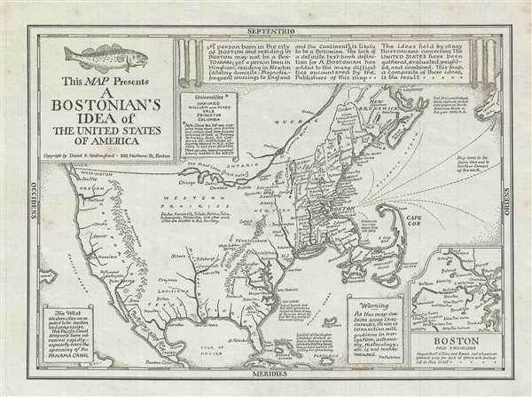

The West: Western cities are reputed to be modern and progressive.The Pacific Coast seaports have advanced rapidly, especially since the opening of the panama Canal.. Wallingford originally issued this map c. 1935 following his move from Chicago to Boston. The present example is a later reissue.
Daniel Kirkwood Wallingford (September 12, 1890 – January 11, 1964) was an American industrial designer and artist. He was born in St. Paul, Minnesota, the son of an architect. Wallingford, first came to national attention as a schoolboy in Indianapolis, when he was so moved by the 1898 explosion of the battleship Maine, off Cuba, that he he donated his life savings of 49 cents to the Dept. of the Navy with a note reading, 'I saved the money myself. I got part of it for having my tooth pulled and I save part of it from Christmas ... I wanted to help build a ship'. For his patriotism a steel-sheathed tugboat was named after him. Wallingford went on to attend Phillips Andover Academy, then Cornell University where studied Architecture and Industrial Design and was a member of the Sigma Chi Fraternity. From 1917 - 1919, he served in World War I (1914 - 1818) and as Lieutenant Colonel of Artillery in World War II (1939 - 1945). He is known for two important maps, New Yorker's View of the United States of America and The Bostonian's View of the United States of America. Both maps were revolutionary in the evolution of the American pictorial map for their satirical depiction of New York and Boston, respectively. The New Yorker's View, Wallingford's first map, was initially issued in 1932 in just 100 prints, which Wallingford distributed as Christmas gifts. The map proved so popular he revised it and proceed a second edition in 1935. Later, in March of 1976, a modified version appeared as a New Yorker cover. Shortly after moving to Boston in 1936, he issued his second map, the The Bostonian's View, also sold via mail order. A third less famous map, A Bookman's Idea of the United States was published in 1938. Wallingford was most likely inspired by John T. McCutcheon's 1922 New Yorker's View of the World and intern inspired a number of subsequent artists including John Roman (Cowboy America) and Ernest Dudley Chase (The United States as Viewed by California). Despite the near iconic popularity of his two famous maps, little is known of Wallingford's personal life. Wallingford died in 1964 and was survived by his wife, Margaret. More by this mapmaker...
Copyright © 2024 Geographicus Rare Antique Maps | Geographicus Rare Antique Maps
This copy is copyright protected.
Copyright © 2024 Geographicus Rare Antique Maps