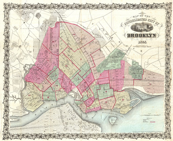
An extremely rare first edition of William Bishop's 1868 pocket map of the city of Brooklyn, New York. In the mid-19th century, fueled by the advent of the steam ferry, which made crossing the East River practical, Kings County experienced an massive population burst. Wealthy and poor alike were quick to abandon the dirty and claustrophobic Manhattan for then suburban lands just across the East River. In 1855 the communities of Brooklyn, Greenpoint, Bushwick and Williamsburg were consolidated by the State of New York into one large city, modern day Brooklyn. It was around this time that the term 'Kings County' began to fall out of popular usage in favor of 'Brooklyn.' By 1865, three years before this map was printed, Brooklyn had become the third largest city in America, following New York and Philadelphia. Here Brooklyn is revealed in the midst of this incredible development. Prospect Park, which was still being built, is shown, as is Greenwood cemetery. The street layout, mimicking the grid system of Manhattan, is shown in considerable detail. Attempts to detail important buildings, ferry crossings, bridges, train lines, and 'plank roads.' Also notes public buildings and lands such as the Lunatic Asylum, the Hospital, the Alms House, the Military Parade Grounds, the Marine Hospital and the Navy Yard. Manhattan appears in the lower left hand corner of the map. North is oriented to the lower left. The whole is surrounding by a decorative vine and leave border. This map was drawn by A. Brown of 47 Nassau Street, New York, for inclusion in Henry McCloskey's 1863 Manual of the City and Corporation of Brooklyn. Cartographically this map references and expands upon the 1846 map of Brooklyn surveyed and prepared by Richard Butt. Of note is the fact that this map, issued just months after Prospect Park's October 1867 completion, is one of the first maps to show Olmsted's design. The only other copy of this map we have been able to identify is the McCloskey edition in the collection of the Brooklyn Public Library. Ours is in superior condition. An extremely rare map.
Also of note, this map comes with a signature panel signed by William Bishop himself and dedicated to WIlliam Marshall, a contemporary of Bishop as well as a known author and lawyer.
Cartographer
William Bishop (fl. c. 1855 - 1877) was the on-and-off city clerk of Brooklyn from about 1860 to the early 1870s. Bishop's primary opponent for the position was newspaperman Henry McCloskey. One of the duties of the city clerk was to publish an annual report detailing the government, progress, urban planning and development of the city. The resulting Manual of the Common Council of the City of Brooklyn was published each year of Bishop's tenure as city clerk. The first Brooklyn Manual was published in 1855 following the consolidation of the city. The Manual was published under various names and in various forms until 1888. More by this mapmaker...
Source
Bishop, William, Manual of the Common Council of the City of Brooklyn, 1864, 1864.
Very good condition. Original folds. Right margin extended. Blank on verso.
New York Public Library Map Div. 01-1836 (Butt Map). Brooklyn Collection, Brooklyn Public Library, Document 51. Bulletin of the New York Public Library, Vol 4, 1902, Page 86.