1719 Chatelain Map of East Asia: China, Korea, Japan, India, East Indies
CarteDeIndes-chatelain-1719
Title
Carte des Indes, dea la Chine and des Iles de Sumatra, Java etc. Dressee sur les Memoires les pulus nouveaux and sur les meilleures Observations, tirees des Relations les plus fideles.
1719 (undated)
21 x 20 in (53.34 x 50.8 cm)
1 : 17098000
Description
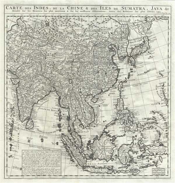
An exceptional 1719 map of the East India Islands by Henri Chatelain. Centered on China, Chatelain's map covers from the Caspian Sea to the semi-mythical Terre de la Compagnie and India to New Guinea. It provides extraordinary detail throughout with topography rendered in profile and numerous geographical and political elements identified. It includes the modern day nations of Japan, China, Korea, India, Indonesia, Tibet, Bhutan, Nepal, Thailand, Cambodia, Burma, Vietnam, Laos, Malaysia, Singapore, and the Philippines, among others. The map offers much of note.
The sea between Japan and Korea, whose name, either the 'Sea of Korea,' 'East Sea,' or the 'Sea of Japan,' is here identified as both 'Mer de Coree' (Sea of Korea) and 'Mer Orientale' (East Sea), Korea has used the term 'East Sea' since 59 B.C., and many books published before the Japanese annexed Korea make references to the 'East Sea' or 'Sea of Korea.' Over time, neighboring and western countries have identified Korea's East Sea using various different terms. The St. Petersburg Academy of Sciences referred to the East Sea as 'Koreiskoe Mope' or 'Sea of Korea' in their 1745 map of Asia. Other seventeenth and 18th century Russian maps alternate between 'Sea of Korea' and 'Eastern Ocean.' The late 18th century Russian and French explorers Adam Johan von Krusenstern and La Perouse called it the 'Sea of Japan,' a term that became popular worldwide. Nonetheless, the last official map published by the Russians name the East Sea the 'Sea of Korea.' The name is remains a matter of historical and political dispute between the two countries.
Hokkaido, or as it is mapped here, Yeco, is connected to the mainland of Asia, reflecting a common misunderstanding about this region that persisted until the late 18th century. Just to the northeast of Japan, separated from the mainland by the Detroit d'Uries, we find Terre de La Compagnie. Terre de la Compagnie, sometimes also called Gamma Land, is essentially an embryonic mapping of the Kuril Islands. These islands were discovered by Maerten de Vries and Cornelis Jansz Coen's 1643 VOC expedition to the region in search of Juan de Gama's land of gold and silver. Various subsequent navigators claim to have seen these lands, but it was left to Vitus Bering to finally debunk the myth. In 1729, Bering spent three days in the region looking Compagnie Island but never found it. These curious islands remained on maps for about 50 years following Bering's voyages until the explorations of Cook confirmed the his findings.
Chatelain maps, but does not name, the apocryphal Lake of Chiamay roughly in what is today Assam, India. Early cartographers postulated that such a lake must exist to source the four important Southeast Asian river systems: the Irrawaddy, the Dharla, the Chao Phraya, and the Brahmaputra. This lake began to appear in maps of Asia as early as the 16th century and persisted well into the mid-18th century. Its origins are unknown but may originate in a lost 16th century geography prepared by the Portuguese scholar Jao de Barros. It was also heavily discussed in the journals of Sven Hedin, who believed it to be associated with Indian legend that a sacred lake linked several of the holy subcontinent river systems. There are even records that the King of Siam led an invasionary force to take control of the lake in the 16th century. Nonetheless, the theory of Lake Chiamay was ultimately disproved and it disappeared from maps entirely by the 1760s. Chatelain offers an interesting take on the lake, suggesting that even as early as 1719, the idea of Chiamay was falling out of favor. Here the lake is mapped, but it is not specifically connected to any of the river systems of Asia.
This chart was issued as plate no. 45 in volume 5 of Chatelain's Atlas Historique.
Cartographer
Henri Abraham Chatelain (1684 - 1743) was a Huguenot pastor of Parisian origins. He lived consecutively in Paris, St. Martins, London (c. 1710), The Hague (c. 1721) and Amsterdam (c. 1728). He is best known as a Dutch cartographer and more specifically for his cartographic contribution in the seminal seven volume Atlas Historique, published in Amsterdam between 1705 and 1720. Innovative for its time, the Atlas Historique combined fine engraving and artwork with scholarly studies of geography, history, ethnology, heraldry, and cosmography. Some scholarship suggests that the Atlas Historique was not exclusively compiled by Henri Chatelain, as is commonly believed, but rather was a family enterprise involving Henri, his father Zacharie and his brother, also Zacharie. More by this mapmaker...
Source
Chatelain, A. H., Atlas Historique, (Amsterdam: L'Honore & Chatelain), vol 4, 1719.
Condition
Very good. Minor wear along original fold lines. Original platemark visible. Minor spotting.
References
National Library of Australia, MAP RM 281.