This copy is copyright protected.
Copyright © 2024 Geographicus Rare Antique Maps
1870 Gilpin and Ebert Map of Colorado showing Gold Regions (Colton edition)
Colorado2-ebertgilpin-1870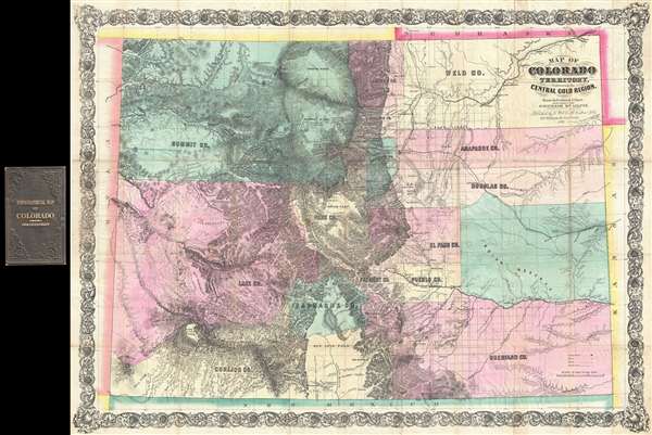

Sahwatch, or San Luis Lake, a body of water some sixty miles in extend, into which flow nineteen streams. This lake has no visible outlet, but is supposed to discharge its surplus water through subterranean channels.And by Gilpin ,
San Luis Lake, extending south from the point of the foothills, occupies the center of the park for sixty miles forming a bowl without any outlet to its waters. It is encircled by immense saturated savannahs of luxuriant grass. Its water surface expands over the savannah during the season of the melting snows upon the sierras and shrinks when the season of evaporation returnsThe lake corresponds to the Closed Basin, where there is no natural outlet for water. During exceptionally wet or warm seasons (when snowmelt can be significant) the valley can flood causing the appearance of a lake. Sahwatch was exploited by Glipin, Blackmore, and others as a 'booster fantasy' to promote settlement in the region. As in many other such land schemes, salt was disguised as sugar. Not only was Sahwatch Lake extremely ephemeral in nature, it was highly alkaline making it unfit for consumption or irrigation.
The Ebert-Gilpin map presents Colorado as politically advanced, divided up into seventeen counties besides an 'Indian Reserve' on the Plains. A great many cities and mining camps are located down the length of the Rockies, and the initial surveys of the General Land Office are indicated. Topography is drawn in to an impressive degree, the latest government maps used to great effect. Principal roads are shown, and notable among them is the 'Road to Salt Lake' reconnoitered in 1861 by E.L. Berthoud [the first published appearance of this route on a printed map].This map was subsequently reissued by Monk in and Colton in 1865. The Colton map in particular is noteworthy for being derived directly from the original 1862 plan. A close study of the two maps suggests that Colton most likely had access to the original printing plate, which he may have simply updated and revised with additional political details and his elaborate trademark acanthus leaf border. The Bancroft Library manuscript collection contains a letter from Gilpin to L. S. Hatch of Denver describing the Colton issue as 'the most excellent, accurate and copious chart, from which all since have been copied'. It has been suggested that Gilpin may have been involved in the Colton production, which explains the similarity between the 1862 plate and the plate from which the present map was printed.
Frederick J. Ebert (January 17, 1822 - May 3, 1888) was a German surveyor and civil engineer active in the American Midwest and in Colorado during the middle to late 19th century. Ebert was born in Brunswick Germany where he studied at the Academy Collegium Corolinum to become a forestry engineer. During the Revolution of 1848 he was an officer under the Duke of Brunswick. Around 1850, as a result of the tribulations that followed the Revolution, he moved to the United States. He lived for one year in Milwaukee, Wisconsin, where is mastered English, before relocating to St. Louis where he found employment as a civil engineer. In 1860 he moved to Denver where he was employed to survey the Kansas Pacific Railroad as far as the headwaters of the Republican River. Later he took work with W. A .H. Loveland to survey a road from Denver to Central City - a particularly mountainous route. He most significant cartographic achievement was the drafting of the first map of Colorado territory, issued in 1862 with the assistance of Surveyor-General John Pierce at the command of Governor Gilpin. This became the definitive map of Colorado until 1871, when more sophisticated maps were released. Afterwards, in 1863 Ebert took a position as the city engineer of Denver. After two terms in this position Ebert became a business man investing in the stock and dairy business as well as organizing the Exchange bank. Later he became involved in Colorado politics and helped draft the Colorado constitution. He died on May 3 of 1888. More by this mapmaker...
William Gilpin (October 4, 1813 – January 20, 1894) was an American explorer, politician, and land speculator. His ardent belief in Manifest Destiny was wedded to odd climatological theories, which led to the creation of a series of maps in his book Mission of the North American People. He was born near Philadelphia to a wealthy family, was privately educated, and graduated from the University of Pennsylvania in 1833. He attended West Point for a year but did not graduate. He was commissioned as a Second Lieutenant in the U.S. Army and served in the Seminole Wars and resigned two years later, in 1838. After leaving the army, Gilpin moved to St. Louis where he became a newspaper editor and opened a law practice. In 1843 Gilpin accompanied John C. Frémont along the Santa Fe Trail and eventually to the Oregon Country. He settled in the Willamette Valley, helped organize the provisional government, and aided in drafting a petition to the United States Congress requesting support for the provisional government. He was charged with carrying the petition to Congress, and on his way to Washington he helped foment "Oregon fever" and promoted the territory. In 1846, Gilpin again joined the army to fight in the Mexican-American War. This time he was commissioned as a Major and participated in the campaign to capture New Mexico. After the end of the war, he returned to Missouri and resumed his law practice. In the early 1860s, the border war between Kansas and Missouri prompted Gilpin to join the Republican party. He was later rewarded for this move by President Lincoln, because hew as appointed governor of the newly formed Colorado Territory in May 1861. Gilpin's time as governor, however, was short lived. Under threat of Confederate invasion at the beginning of the Civil War, Gilpin created a military regiment without authorization from the federal government. Since he did not have the money to do so, Gilpin issued $375,000 in drafts on the federal treasury. At first, this move was supported by the people of Colorado, but once it became clear that the treasury was not going to validate the drafts, things quickly turned sour for Gilpin. Petitions began to be circulated calling for his removal. Despite the controversy, the creation of the 1st Colorado Volunteers proved to be fortuitous after the Confederates launched an invasion from the New Mexico Territory in the spring of 1862. The Colorado volunteers played a critical role in routing the Texans at the Battle of Glorieta Pass, which became known as the 'Gettysburg of the West'. Even so, Gilpin was removed in April 1862 by President Lincoln. Gilpin died in Denver in 1894 after being run over by a horse and buggy. Learn More...
Joseph Hutchins Colton (July 5, 1800 - July 29, 1893), often publishing as J. H. Colton, was an important American map and atlas publisher active from 1833 to 1897. Colton's firm arose from humble beginnings when he moved to New York in 1831 and befriended the established engraver Samuel Stiles. He worked under Stiles as the 'Co.' in Stiles and Co. from 1833 to 1836. Colton quickly recognized an emerging market in railroad maps and immigrant guides. Not a cartographer or engraver himself, Colton's initial business practice mostly involved purchasing the copyrights of other cartographers, most notably David H. Burr, and reissuing them with updated engraving and border work. His first maps, produced in 1833, were based on earlier Burr maps and depicted New York State and New York City. Between 1833 and 1855 Colton would proceed to publish a large corpus of guidebooks and railroad maps which proved popular. In the early 1850s Colton brought his two sons, George Woolworth Colton (1827 - 1901) and Charles B. Colton (1832 - 1916), into the map business. G. W. Colton, trained as a cartographer and engraver, was particularly inspired by the idea of creating a large and detailed world atlas to compete established European firms for the U.S. market. In 1855, G.W. Colton issued volume one the impressive two volume Colton's Atlas of the World. Volume two followed a year later. Possibly because of the expense of purchasing a two-volume atlas set, the sales of the Atlas of the World did not meet Colton's expectations and so, in 1856, the firm also issued the atlas as a single volume. The maps contained in this superb work were all original engravings and most bear an 1855 copyright. All of the maps were surrounded by an attractive spiral motif border that would become a hallmark of Colton's atlas maps well into the 1880s. In 1857, the slightly smaller Colton's General Atlas replaced the Atlas of the World, which lacked the border. Most early editions of the General Atlas published from 1857 to 1859 do not have the trademark Colton spiral border, which was removed to allow the maps to fit into a smaller format volume. Their customers must have missed the border because it was reinstated in 1860 and remained in all subsequent publications of the atlas. There were also darker times ahead, in 1858 Colton was commissioned at sum of 25,000 USD by the government of Bolivia to produce and deliver 10,000 copies a large format map of that country. Although Colton completed the contract in good faith, delivering the maps at his own expense, he was never paid by Bolivia, which was at the time in the midst of a series national revolutions. Colton would spend the remainder of his days fighting with the Bolivian and Peruvian governments over this payment and in the end, after a congressional intervention, received as much as 100,000 USD in compensation. Nonetheless, at the time it must have been a disastrous blow. J. H. Colton and Company is listed as one of New York's failed companies in the postal record of 1859. It must have been this that led Colton into the arms of Alvin Jewett Johnson and Ross C. Browning. The 1859 edition of Colton's General Atlas lists Johnson and Browning as the 'Successor's to J. H. Colton' suggesting an outright buyout, but given that both companies continued to publish separately, the reality is likely more complex. Whatever the case may have been, this arrangement gave Johnson and Browning access to many of Colton's map plates and gave birth to Johnson's New Illustrated (Steel Plate) Family Atlas. The Johnson's Atlas was published parallel to Colton's atlas well in to the 1880s. The Colton firm itself subsequently published several other atlases including an Atlas of America, the Illustrated Cabinet Atlas, the Octavo Atlas of the Union, and Colton's Quarto Atlas of the World. They also published a large corpus of wall maps, pocket maps, and guides. The last known publications of the Colton firm date to 1897 and include a map and a view, both issued in association with the Merchant's Association of New York. Alice M. Colton married August R. Ohman (May 3, 1859 - April 22, 1934) on January 5, 1897. In 1898, Ohman joined the Colton firm, which continued to publish as Colton, Ohman & Co. until 1901. Learn More...
Copyright © 2024 Geographicus Rare Antique Maps | Geographicus Rare Antique Maps
This copy is copyright protected.
Copyright © 2024 Geographicus Rare Antique Maps