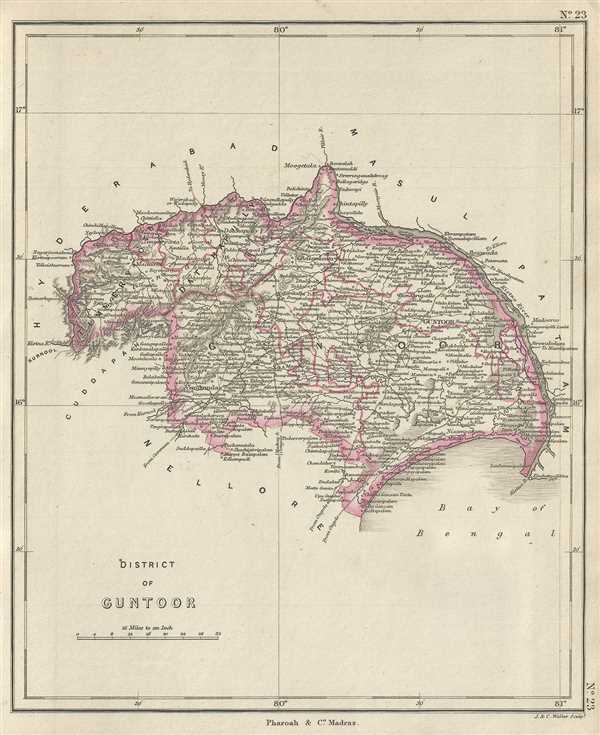
This is a lovely example of the 1854 Pharoah and Company map of the Guntur District in the Indian state of Andhra Pradesh. The map covers the district from Chinnaganjam north along the Krishna River and west as far as Kurnool.
At the time this map was made, the district was part of the Madras Presidency under the control of the British East India Company. The history of this region however dates back to the stone ages and holds significance in the Buddhist religion and is believed to be the place where Gautam Buddha performed the first Kalachakra ceremony. It was also in Guntur that the French astronomer Jules Janssen first detected Helium in 1868.
This map was engraved by J. and C. Walker and issued as plate no. 23 by Pharoah and Company in their 1854 Atlas of Southern India.
Source
Pharoah and Company, An Atlas of the Southern Part of India including Plans of all the Principal Towns and Cantonments, reduced from the Grand Trigonometrical Survey of India shewing also The Tenasserim Provinces, (Madras) 1854.
The Pharoah and Company Atlas of Southern India was published around 1854. The medium format 4to atlas contained some 70 maps focusing on the southern part of Indian and the Tanasserium Province, or Burma. The atlas was engraved an printed in London by J. and C. Walker, but seems to have been issued only in Madras, India, by J. B. Pharoah and Company. The atlas claims to have been "reduced from the Grand Trigonometrical Survey of India," and, in fact the survey did provide a framework for the atlas, but little of the actual cartographic detail. The atlas is rather novel in that it has universal scale of 16 miles to the inch (1 : 1013760) for most of its regional maps. In addition to its regional maps, the atlas also contained 21city plans. These plans are some of the only obtainable mid-195h century maps of many South Indian cities. It also contained a rare map of Singapore.
Very good. Minor foxing.
OCLC: 710810053.