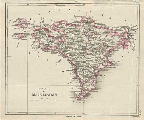
This is a nice example of Pharoah and Company’s 1854 map of the Masulipatam or Krishna District on Andhra Pradesh, India. It covers from the mouth of the Krishna River north to the Godavari River and Raghavapuram and notes important towns, roads, rivers, and topography. The first headquarters of the British was in Masulipatnam when they established their settlement there in 1611 and built their factory here. The headquarters would later move to Madras in 1641, but the town would remain an important trading port for the French, British and Dutch ships.
This map was engraved by J. and C. Walker and issued as plate no. 24 by Pharoah and Company in their 1854 Atlas of Southern India.
Source
Pharoah and Company, An Atlas of the Southern Part of India including Plans of all the Principal Towns and Cantonments, reduced from the Grand Trigonometrical Survey of India shewing also The Tenasserim Provinces, (Madras) 1854.
The Pharoah and Company Atlas of Southern India was published around 1854. The medium format 4to atlas contained some 70 maps focusing on the southern part of Indian and the Tanasserium Province, or Burma. The atlas was engraved an printed in London by J. and C. Walker, but seems to have been issued only in Madras, India, by J. B. Pharoah and Company. The atlas claims to have been "reduced from the Grand Trigonometrical Survey of India," and, in fact the survey did provide a framework for the atlas, but little of the actual cartographic detail. The atlas is rather novel in that it has universal scale of 16 miles to the inch (1 : 1013760) for most of its regional maps. In addition to its regional maps, the atlas also contained 21city plans. These plans are some of the only obtainable mid-195h century maps of many South Indian cities. It also contained a rare map of Singapore.
Very good. Minor foxing.
OCLC: 710807654.