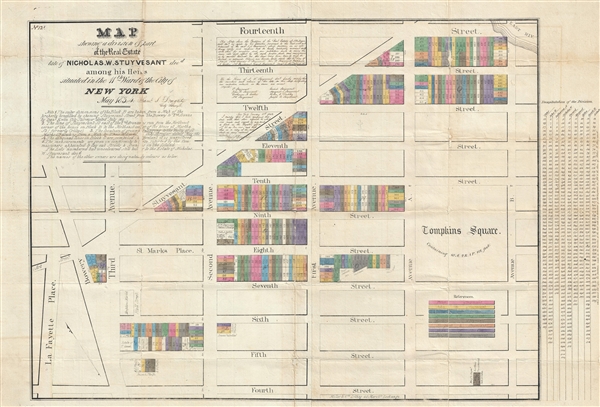
A rare and important early cadastral map of New York City's East Village drawn and hand annotated by Samuel S. Doughty. This map covers from La Fayette Please (Lafayette Street / Astor Place) to Avenue B and from 14th Street to 4th Street, including Tompkins Square Park. Today this area is among the most vibrant of all New York City neighborhoods and a favorite of both locals and tourists alike.
This map was prepared to illustrate the lands in the then 11th Ward owned by Nicholas W. Stuyvesant (c. 1769 – 1833). When Stuyvesant died in 1833 the lands were parceled out to his heirs. Each decedent's bequest is here highlighted in color with a corresponding key situated in the lower right.
The source for this map is a manuscript survey completed by Samuel Doughty in 1834. That document is preserved in the city register's office as document 81. A lithographed version of the map, currently offered, was subsequently issued by Miller and Company of 45 Merchants Exchange, New York, on the behest of the Doughty and the City Surveyor's Office. This lithographic issue was used to resolve a number of subseuqent legal disputes. The present example was prepared in 1842 and signed and certified by Samuel Doughty
- RED - Peter Stuyvesant
- YELLOW - John R. Stuyvesant
- BLUE - Catherine Ann Catlin
- GREEN - Nicholas William Stuyvesant
- BROWN - Gerard Stuyvesant
- ORANGE - Margaret I. Stuyvesant
- PURPLE - Helen C. Dudley
- GREY - Joseph R. Stuyvesant
The presence of an uncolored version of this map in the archives of Columbia University suggests that colored versions of this map were produced on request by the City Surveyor's office, in this case by Doughty himself. The present map appears to have been submitted as evidence in a court case heard in January of 1842. Doughty's extensive annotation attests to the accuracy of the map when compared to his own manuscript original. Additional manuscript data appears to the right of the map where the bequests of each Stuyvesant heir are identified by lot number. There is also a manuscript note on the verso referring to the 1842 court case in which this was used.
A important and unique discovery.
Cartographer
Samuel Stillwell Doughty (1810 - July, 1888) was a New York City surveyor active in the middle part of the 19th century. Doughty was the son of another New York City Surveyor, Edward Doughty (1789 - 1863), from whom he learnt the trade. Doughty produced numerous city surveys and cadastral maps used for property transfers and legal disputes. From 1844 to about 1846 he also held the position of New York City Street Commissioner. Samuel was highly significant in the early development of New York City. He laid out may of the streets in upper New York as well as assisted on the initial surveys of Central Park. In 1880 he published short biography of his father, Edward Doughty. He resided on 28th Street near Broadway, New York City. More by this mapmaker...
Good. Map exhibits wear and some (repaired with minor manuscript infill) loss at fold intersections. Backed with archival tissue.
OCLC 58661108. Columbia University, Seymour B. Durst Old York Library, AA735 N4 D75 FFF. Clio 10390845.