1867 Hughes Map of Egypt and Germany in Antiquity

EgyptGermany-hughes-1867
$100.00
Arabia Petraea and Part of Egypt including the Delta.  Germania Magna with the Provinces on the Upper Danube. - Main View
Processing...

1867 Hughes Map of Egypt and Germany in Antiquity

EgyptGermany-hughes-1867

$100.00

Title


Arabia Petraea and Part of Egypt including the Delta. Germania Magna with the Provinces on the Upper Danube.
  1867 (undated)     13 x 10 in (33.02 x 25.4 cm)     1 : 3380000

Description


This is an unusual 1867 map by William Hughes featuring Egypt and Germany in antiquity. Essentially two maps on a single sheet, the top map focuses on Egypt, including the Sinai Peninsula. This map, centered on the Nile Valley, identifies the sites of ancient towns, villages, pyramids (including the Pyramids near Memphis) and lakes. It features both ancient and contemporary place names for each destination - an invaluable resource for scholars of antiquity. The map depicts the supposed course of the wandering of the Israelites following the Exodus, as they fled out of Egypt, across the Red Sea, and subsequently spent the next forty years wandering in the Sinai before migrating into the Promised Land by crossing the Jordan River just north of the Dead Sea. Possibly this map's most interesting aspect is its presentation of the ancient Lake Moeris, now just a small lake called Birket Qarun, and the legendary 'Labyrinth' near modern day Hawara. The lost Labyrinth was described by many classical authors including Herodotus, Strabo, Diodorus and Pliny. A sprawling megalithic complex designed by Imandes for the Pharoh Amenemhet III, the Labyrinth is believed to have contained thousands of rooms filled with hieroglyphs and ancient Egyptian sculptures. Several archeological surveys have been undertaken to unearth the labyrinth, but so far no findings have been confirmed.

The lower map features ancient Germany. The map covers the lands of the Germanic peoples prior to the fall of the Roman Empire from modern day Denmark to Switzerland and from Belgium to Poland. This particular map focuses on the regions of Germania Magna (Greater Germany) which resisted all attempts at Roman rule.

At the time, 'Germania' was a name given to the lands between the Alps and the Baltic Sea. The region was inhabited mainly by Germanic, but also Celtic, Baltic, Scythian, proto-Slavic peoples. This map identifies many of the old tribes, including the Quadi, Marcomanni, Suevi, Angli, Saxones, Chatti (Hessians), and several others. Caesar Augustus described the Germanic tribesmen north of the Roman Empire as extremely savage and a threat to Roman Gaul. His Roman Legions, led by Generals Germanicus and Tiberius, conquered Germania Magna to the River Elbe, and occupied it until the Romans were defeated at the Battle of the Teutoburg Forest, in 9AD. The Romans withdrew, establishing the Rhine and the Danube Rivers as Germanic boundary of the Roman Empire.

Tacitus wrote in Germania in 98 BC:
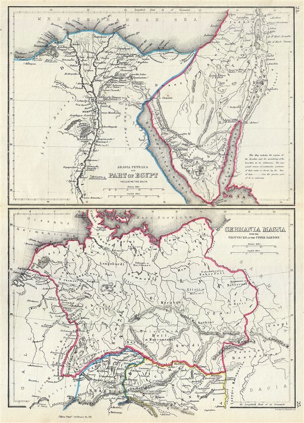
…they affirm Germania to be a recent word, lately bestowed. For those who first passed the Rhine and expulsed the Gauls, and are now named Tungrians, were then called Germani. And thus by degrees the name of a tribe prevailed, not that of the nation; so that by an appellation at first occasioned by fear and conquest, they afterwards chose to be distinguished, and assuming a name lately invented were universally called Germani .
This map was created by William Hughes, printed by J. Bien and engraved by G.E. Sherman, for issued as plates 24 and 25 in Sheldon and Company's An Atlas of Classical Geography.

CartographerS


William Hughes (c. 1818 - May 21, 1876) was a cartographer, engraver, lithographer, printer, and publisher active in London during the middle part of the 19th century. Hughes enjoyed and long and varied cartographic career. He was elected a Fellow of the Royal Geographical Society in 1838 and, from about 1840, taught geography and mapmaking at St. Johns College for Civil Engineers. He later taught the same at both Queens College and Kings College, London. For a time he was employed as a map librarian for the British Museum. Hughes began engraving maps around 1839 and worked with most of the prominent British map and atlas publishers of his era, including but not limited to Charles Knight, A. and C. Black, George Philip, William Cassell, and others. More by this mapmaker...


404 Not Found

Server Error

404

Page Not Found

This page either doesn't exist, or it moved somewhere else.


That's what you can do

Learn More...


Sherman and Smith (fl. c. 1829 - 1855), sometimes working as Stiles, Sherman & Smith, were American engravers active in New York City during the middle part of the 19th century. The firm including John Calvin Smith (surveyor and engraver), George E. Sherman, and sometimes, Samuel Stiles. Their work primarily focused on government publications, including the maps and engravings prepared to illustrate the official records of the 1838-42 United States Exploring Expedition (U.S. Ex. Ex.), maps issued for the Army Corps of Topographical Engineers, and various U.S. Coast Survey Charts. They also engraved privately for Thomas Bradford and John Disturnell, among others. Sherman and Smith maintained offices at the corner of Broadway and Liberty Street in New York City and were highly regarded as the finest cartographic engravers in the city. Their non-cartographic legacies include George Inness, who apprenticed with them for two years before going on to become a well regarding American landscape painter of the Hudson River School. Learn More...

Source


Sheldon and Company, An Atlas of Classical Geography constructed by William Hughes and edited by George Long, (New York) 1867.    

Condition


Very good. Minor wear and toning along original centerfold.