Title
Europe.
1835 (undated)
17 x 21 in (43.18 x 53.34 cm)
1 : 10138000
Description
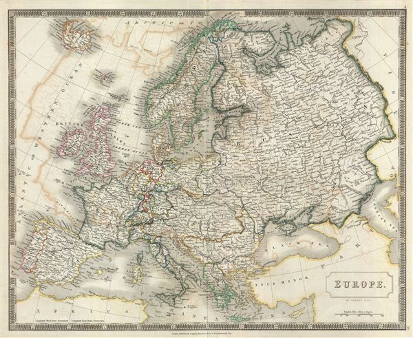
This is a beautiful map of Europe from Sidney Hall's extremely scarce 1835 New General Atlas. It covers the entire continent from the Atlantic Ocean to the Ural Mountains and from the Arctic Ocean to northern Africa and Turkey, including Iceland. It includes Spain, Portugal, France, Italy, European Russia, Sweden, Denmark, Norway, Germany, Ireland, Great Britain, Turkey in Europe and Greece. Towns, rivers, mountains, steppes, islands, and various other important topographical details are noted. Elevation throughout is rendered by hachure and political and territorial boundaries are outlined in color. Several battle grounds are marked throughout, including the Battle of Groix under Admiral Lord Bridport in 1795, and various sites for the Battle of Trafalgar in 1805, among others. It shows the Austrian Empire at its height, the many states of the German Confederacy, and a pre-Garibaldi Italy split into numerous small duchies and states. During this time, The British Empire rose to its peak while the Ottoman Empire was declining. Poland is notable absent, having been absorbed and divided by neighboring Russia, Austria, and Prussia. Issued following the defeat of Napoleonic France and the Congress of Vienna, Europe is shown under a new peaceful balance of power, centered on the five most important powers (also referred to as the five 'Great Powers'): the United Kingdom, France, Russia, Prussia and the Austrian Empire. Alas, the 'peace' was but an illusion as the treaties ending the Napoleonic Era were inherently flawed. Old rivalries festered and nationalism, liberalism, revolution (industrial and otherwise) was once again on the rise throughout Europe.
Sidney Hall's New General Atlas was published from 1830 to 1857, the first edition being the most common, with all subsequent editions appearing only rarely. Most of the maps included in the first edition of this atlas were drawn between 1827 and 1828 and are most likely steel plate engravings, making it among the first cartographic work to employ this technique. Each of the maps in this large and impressive atlas feature elegant engraving and an elaborate keyboard style border. Though this is hardly the first map to employ this type of border, it is possibly the earliest to use it on such a large scale. Both the choice to use steel plate engraving and the addition of the attractive keyboard boarder are evolutions of anti-forgery efforts. Copper plates, which were commonly used for printing bank notes in the early 19th century, proved largely unsuitable due to their overall fragility and the ease with which they could be duplicated. In 1819 the Bank of England introduced a £20,000 prize for anyone who could devise a means to print unforgeable notes. The American inventors Jacob Perkins and Asa Spencer responded to the call. Perkins discovered a process for economically softening and engraving steel plates while Spencer invented an engraving lathe capable of producing complex patters repetitively - such as this keyboard border. Though Perkins and Spenser did not win the prize, their steel plate engraving technique was quickly adopted by map publishers in England, who immediately recognized its value. Among early steel plate cartographic productions, this atlas, published in 1830 by Longman Rees, Orme, Brown & Green stands out as perhaps the finest. This map was issued by Sidney Hall and published by Longman Rees, Orme, Brown & Green of Paternoster Row, London, in the 1835 edition of the Sidney Hall New General Atlas.
Cartographer
Sidney Hall (1788 - 1831) was an English engraver and map publisher active in London during the late 18th and early 19th centuries. His earliest imprints, dating to about 1814, suggest a partnership with Michael Thomson, another prominent English map engraver. Hall engraved for most of the prominent London map publishers of his day, including Aaron Arrowsmith, William Faden, William Harwood, and John Thomson, among others. Hall is credited as being one of the earliest adopters of steel plate engraving, a technique that allowed for finer detail and larger print runs due to the exceptional hardness of the medium. Upon his early death - he was only in his 40s - Hall's business was inherited by his wife, Selina Hall, who continued to publish under the imprint, "S. Hall", presumably for continuity. The business eventually passed to Sidney and Selina's nephew Edward Weller, who became extremely prominent in his own right. More by this mapmaker...
Source
Hall, S., A New General Atlas, with the Divisions and Boundaries, 1835.
Condition
Very good. Original platemark visible. Minor wear along original centerfold. Some offsetting. Blank on verso.
References
Philips (Atlases) 758. Ristow, W., American Maps and Mapmakers: Commercial Cartography in the Nineteenth Century, p. 303-09.