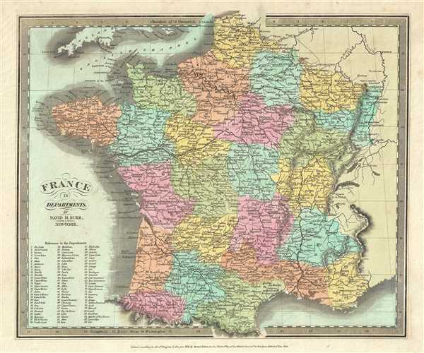
This beautiful first edition map of France was issued by David Burr in 1832. It depicts the Kingdom of France showing its various departments. Towns, river, mountains and various other important topographical details are noted. Elevation throughout is rendered by hachure. A reference to the departments is included in the lower left quadrant.
Until 1790 France was divided into 40 provinces based on local loyalties and feudal histories. On March 4th of 1790 the National Constituent Assembly reorganized the Provinces with what the Assembly deemed a more rational political structure. The new department system was intended to deliberately break up France's historical regions in an attempt to erase cultural differences and build a more homogeneous nation. Initially there were 83 departments but by 1800 that number increased to roughly 130, of which 84 are listed here. Many of the departments that were created in 1790 remain administrative districts to this day.
According to Ristow, although Burr is credited on the title page, he left this atlas incomplete. He was appointed as topographer to the U.S. Post Office, and of the sixty-three maps finally included in this atlas, only completed eight. The rest of the maps were then completed by Illman and Pilbrow in Burr's style. The map was ‘Entered according to act of Congress in the year 1832 by David H. Burr in the Clerk’s office of the District Court for the Southern District of New York’, but not published until the atlas was released in 1835. Published by D. S. Stone in Burr’s New Universal Atlas.
Cartographer
David Hugh Burr (August 18, 1803 - December 25, 1875) of one of the first and most important truly American cartographers and map publishers. Burr was born in Bridgeport Connecticut in August of 1803. In 1822 Burr moved to Kingsboro, New York to study law. A year and a half later he was admitted to the New York Bar association. Burr must have questioned his choice of careers because shortly after being admitted to the Bar, he joined the New York State Militia. Though largely untrained in the art of surveying, Burr was assigned to work under Surveyor General of New York, Simeon De Witt, to survey several New York Roadways. Seeing a window of opportunity, Burr was able to negotiate with the governor of New York at the time, De Witt Clinton, to obtain copies of other New York survey work in order to compile a map and Atlas of the state of New York. Recognizing the need for quality survey work of its territory, the government of New York heartily endorsed and financed Burr's efforts. The resulting 1829 Atlas of the State of New York was the second atlas of an individual U.S. state and one of the most important state atlases ever produced. Burr went on to issue other maps both of New York and of the United States in general. In cooperation with publishing firm of Illman & Pillbrow, he produced an important New Universal Atlas and, with J.H. Colton, several very important maps of New York City. In recognition of this work, Burr was appointed both "Topographer to the Post office" and "Geographer to the House of Representatives of the United States". Later, in 1855, Burr was assigned to the newly created position of Surveyor General to the State of Utah. Burr retired from the position and from cartographic work in general in 1857 when light of some of his financial misdeeds and frauds came to light. He was accused of submitting false expense reports and underpaying employees, among other indiscretions. More by this mapmaker...
Source
Burr, David H., A New Universal Atlas; Comprising Separate Maps of All the Principal Empires, Kingdoms & States Throughout the World: and forming a distinct Atlas of the United States, (New York: D. S. Stone) 1835 (First Edition).
Burr's New Universal Atlas was first published in 1835. It is one of the first great American commercial atlases and one of the most important to appear before the Civil War. Burr was most likely initially inspired to publish a 'universal atlas' in pursuit a more general audience by the success of his 1829 Atlas of New York State. He began work on the Universal Atlas sometime around 1830. By 1832 he had copyrighted eight new maps for the work. Around this time he accepted a position as topographer and cartographer for the United States Postal Department and was thus unable to finish the atlas personally. Instead, while retaining editing rights and overall ownership, Burr passed much of the production work to his engravers Thomas Illman and Edward Pillbrow. The first edition of the atlas was completed in 1835 and published by D. S. Stone of New York. A second edition, published by William Hall, appeared in the following year, 1836. Both editions featured 63 maps, the first part of the book being dedicated to world maps and the second part to the Americas, particularly the United States. Some of 1836 editions features outline rather than the distinctive full color common in the first edition. The plates for the atlas were later sold to Jeremiah Greenleaf who expanded the atlas to 65 maps and issued editions in 1840, 1842, and 1848.
Very good. Minor foxing. Original platemark visible. Minor edge wear.
Rumsey 4628.009. Philips (Atlases) 771.