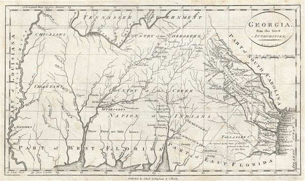
One of the earliest obtainable specific maps of Georgia, this is a very attractive example of John Reid's 1796 presentation of Georgia. The map covers from the Atlantic Ocean to the Mississippi and from the Tennessee River to the Gulf of Mexico, covering all of modern day Georgia, Alabama, and Mississippi as well as parts of Florida and Tennessee. The map reflects the somewhat limited knowledge of the region available at the time of publication. European settlement of Georgia is at this point confined to those lands to the east of the Oconee and Altamaha Rivers – where a clear country structure and numerous large towns, including Savannah, are clearly discernable. West of these rivers, the lands are fully dominated by American Indian villages and tribes, but little is known of their deportment beyond easily accessible villages situated on major trade routes and riverways. Several trade routes between coastal communities and American Indian communities are noted, including one broad network extending all the way to the Mississippi River. Natchez is noted, but is not clearly connected to any of the known trade routes presented. The map identifies the Cherokee, Chicasaw, Chactaw, Muskogee, Creek and Seminole. It also attempts to address various border disputes, such as the annexation of a significant part of Creek territory, here identified as Tallassee County, in the 1790 Treaty of New York.
This is the first edition of Reid's Georgia According to the Latest Authorities. It is identifiable as such by the imprint, 'J. Reid, J. L. Wayland & C. Smith' which appears just below the bottom border. In subsequent editions only J. Reid, or nothing at all, is printed in at this location. The present map was engraved by Benjamin Tanner of New York. This map was published in John Reid's 1796 American Atlas. Although Reid's atlas is derived from the work of of London cartographer John Russell, this and 14 other maps from the atlas focusing on American states and regions, are new engravings that first appeared in this atlas. Cartographically the map is clearly derived from John Carey's map of 1795 but a close examination reveals it to be an entirely different, although visually similar, plate.
CartographerS
John Reid (fl. c. 1775 - c. 1800) was an American bookseller and commercial mapmaker active in New York during the latter part of the 18th century. He is known for publishing the second American commercial atlas, the 1795 American Atlas. Unlike most American printers of his day, which were based in Philadelphia, Reid maintained his office at 106 Water Street, New York City. Little else is known of Reid's life and career. More by this mapmaker...
Benjamin Tanner (March 27, 1775 - c. 1846) was an American engraver active in the late 18th and early 19th centuries. Benjamin was the brother of the more prominent younger brother, the Philadelphia engraver Henry S. Tanner. Benjamin, who was based in New York City for most of his early career. Although is master is unknown, he most likely trained under the New York mapmaker Peter R. Maverick. His earliest work dates to 1792 and his is known to have engraved many of the maps for Reid's 1775 An American Atlas. Around 1811 he relocated to Philadelphia and established a business with his brother as a general engraver and map publisher. He also worked as a bank note publisher under the imprint of Tanner, Vallance, Kearny & Co. perfecting the stereographic technique until roughly 1846. Learn More...
Source
Reid, J., An American Atlas (John Reid: New York) 1796.
An American Atlas, published by John Reid in 1796 is the second commercial atlas published in the United States. It is considered among the rarest and most interesting of all American atlases. Reid's atlas was originally issued as an accompaniment to Winterbotham's Historical, Geographical, Commercial and Philosophical View of the United States, but easily stands on its own as a production of outstanding merit. The original atlas contained 20 or 21 maps, including detailed engraved maps of North and South America, and the United States; and individual maps of New Hampshire, Maine, Massachusetts, Vermont, Rhode Island, Connecticut, New York, New Jersey, Pennsylvania, Delaware and Maryland, Virginia, Kentucky, North Carolina, South Carolina, Georgia, Tennessee, and the West Indies. The continent maps, the general map of the United States, and those of Kentucky and Washington are after maps appearing in London editions of Winterbotham; the remaining maps are unique to this work. Of the new maps, most are drawn loosely from those maps appearing in John Carey's 1795 American Atlas or, in the case of the Kentucky map, from the J. Russell's work for the 1795 London edition of Winterbotham. Most of the maps in Reid's American Atlas were engraved by Benjamin Tanner, brother to Henry S. Tanner, the most prominent map engraver in the United States. Others were engraved by David Martin, D. Anderson, John Scoles, and John Roberts. Some examples of the The American Atlas also featured the scarce Andrew Ellicott map of Washington D.C. It is noteworthy that most examples of the atlas are printed on inconsistent stock and suffer from severe condition issues due to the fact that the individual maps were printed in various different locations then shipped to Reid for binding. Reid's An American Atlas exists in only one edition and is unlikely to have been successful given the scarcity of all examples today.
Very good. Minor repairs upper margin. Minor repaured puncture on the Rocky River near the S in 'Tennessee.'
Rumsey 0845.018. Library of Congress, Map Division, G3860 1795 .B3. Boston Public Library, Leventhal Center, G3920 1796 .T36. Phillips (America) page 296. Wheat, James Clements and Brun, Christian F., Maps and Charts Published in America before 1800; a Bibliography, 615.