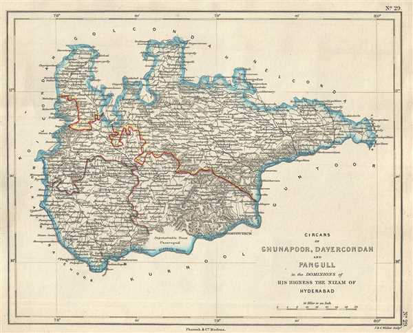
This is an uncommon 1854 Pharoah and Company map of the Circars or Sarkars of Ghunapoor, Davercondah and Pangull under the Nizam of Hyderabad. The map covers what is today part of the Districts of Nalgonda and Mahbubnagar in the Indian state of Telangana. The map notes important towns, rivers, roads, and topography.
Circar or Sarkar were historical division of a province used in the Mughal states of India. The Pangal, Devarakonda and Ghanpur regions were part of the princely State of Hyderabad, ruled by the Nizam under the British East India Company. The princely state was ruled by a hereditary Nizam from 1724 to 1948, until' the Nizam was overthrown by the Indian Armed Forces following its independence.
This map was engraved by J. and C. Walker and issued as plate no. 29 by Pharoah and Company in their 1854 Atlas of Southern India.
Source
Pharoah and Company, An Atlas of the Southern Part of India including Plans of all the Principal Towns and Cantonments, reduced from the Grand Trigonometrical Survey of India shewing also The Tenasserim Provinces, (Madras) 1854.
The Pharoah and Company Atlas of Southern India was published around 1854. The medium format 4to atlas contained some 70 maps focusing on the southern part of Indian and the Tanasserium Province, or Burma. The atlas was engraved an printed in London by J. and C. Walker, but seems to have been issued only in Madras, India, by J. B. Pharoah and Company. The atlas claims to have been "reduced from the Grand Trigonometrical Survey of India," and, in fact the survey did provide a framework for the atlas, but little of the actual cartographic detail. The atlas is rather novel in that it has universal scale of 16 miles to the inch (1 : 1013760) for most of its regional maps. In addition to its regional maps, the atlas also contained 21city plans. These plans are some of the only obtainable mid-195h century maps of many South Indian cities. It also contained a rare map of Singapore.
Very good. Minor foxing.
OCLC: 711966378.