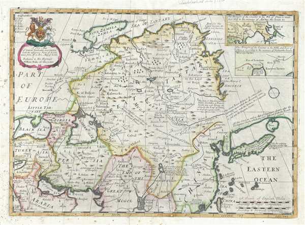
This is a decorative 1712 map of Tartary by Edward Wells of Oxford. It covers from the Black Sea and Turkey east as far as Japan. It extends north to Nova Zembla and south to the Ganges Delta. When Wells drew this map, this part of the world was relatively unknown. The Caspian Sea is ill-formed and erroneously oriented, a common error dating to the 17th century maps. The Island of Nova Zembla (Nouvelle Zemble) is rendered with an unexplored eastern shore. Korea and Taiwan also appear in a speculative shape. Two insets in the top right quadrant of the map depict the NE and NNE of China. A decorative title cartouche appears in the top left quadrant.
This, like many other Wells maps, is dedicated to Prince William, Duke of Gloucester and son of Queen Anne, who, when this map was being prepared, was a student at Oxford. Engraved by R. Spofforth and published by T. Bonwicke for the 1712 edition of Edward Wells' Atlas, A New Sett of Maps both of Ancient and Present Geography.
Cartographer
Edward Wells (1667 - 1727) was an English mathematician, geographer, and classical scholar based at Christ Church College, Oxford. Wells trained for the ministry but quickly found himself unsuited to religious life and instead applied for an academic position at Oxford, where he authored numerous well respected works on a wide range of mathematical and scientific topics. He tutored Prince William, the sickly son of Queen Anne, who was likely about 11 at the time this map was prepared. Wells dedicated nearly all of the maps in his atlas, A New Sett of Maps both of Ancient and Present Geography, to the young prince - quite possibly posthumously, as William died in July of 1700 shortly prior to the publication of the atlas. Nonetheless, Wells' geography proved popular and was published in number editions well into the 1730s. More by this mapmaker...
Source
Wells, E., A New Sett of Maps both of Ancient and Present Geography, (London, T. w. Bonwicke) c. 1712.
A New Sett of Maps both of Ancient and Present Geography was published by Edward Wells in various editions between 1701 and 1730. The publication contained some 40 maps all of which were dedicated to Prince William, Duke of Gloucester. Wells tutored the young prince at Christchurch, Oxford and seems to have developed a close relationship with him. At just 11 years of age, William died in 1700 and never had the opportunity to see the published work that he inspired. The atlas was intended for educational purposes with a focus on school use.
Very good. Some wear along original centerfold. Original platemark visible. Some foxing. Minor creasing.
Rumsey 11181.032.