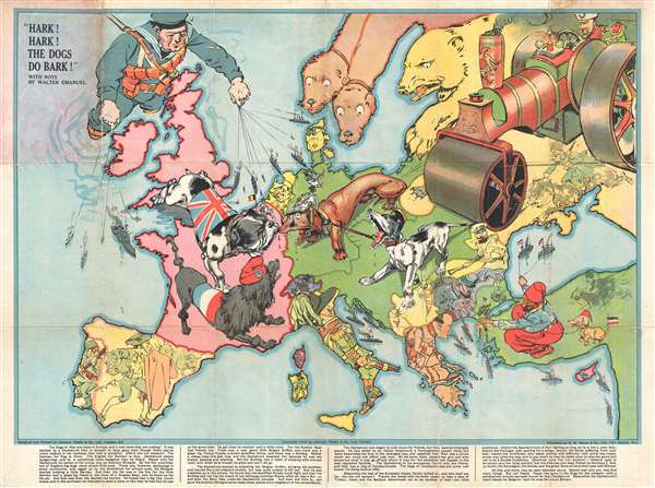
An iconic serio-comic map by Johnson, Riddle, and Company issued shortly after the outbreak of World War I. The map covers all of Europe from the Atlantic to the Black Sea and from Scandinavia to Italy. Superimposed on the map are a host of dogs, as well as other animals and several human figures. The lighthearted nature of the map captures with overall optimism in England about the war. It was believed that British naval superiority would end the war quickly, some said in as little as six weeks.
This map was issued shortly after French and British forces halted the German advance at the August 23 Battle of Mons. They are represented here as a British Bulldog and a neatly groomed French Poodle taking on a distinctively submissive posture. Facing them are a rather earnest looking German Dachshund who is chained to a mongrel dog, representing the ethnically diverse Austrian Empire. The two dominant human figures on the map are England and Russia. England is symbolized by Winston Churchill, then Lord of the Admiralty, who plays puppet master with the British Navy directing it to blockade Germany. Russia, on the opposite corner of the map, is poised to steam roll over Europe. The Balkans are a stirred up hornet's nest.
All in all, the map succinctly reveals the causes of the war and the underlying tensions between nations that led to the conflict. For any who need additional elucidation, there is a wonderful write-up at the base of the map by British humorist Walter Emanuel explaining the message of the map is great detail.
It has been postulated that this map may have been made for children and passed out at schools, thus accounting for its scarcity today. Sadly, as the war developed publishers like Johnson, Riddle and Company became more focused on war propaganda and recruitment efforts than educational humor.
Cartographer
George Washington Bacon (1830 - 1922) was a London based book and map publisher active in the mid to late 19th century. Bacon's firm G.W. Bacon and Co. purchased the plates created by Edward Weller for the Weekly Dispatch Atlas then modified and updated them for several of their own important atlases, including The New Ordnance Atlas of the British Isles. In 1893, Bacon & Co. acquired the map publishing business of J. Wyld. Then, around the turn of the century, Bacon & Co. itself was folded into the Scottish publishing house of W.& A.K. Johnston. More by this mapmaker...
Good. Backed on archival tissue. Some wear on original fold lines. Discoloration in the upper left corner where originally attached to red binder.
OCLC 78847141. Bryers, T., and Harper, T., A History of the 20th Century in 100 Maps, p. 46-47. Baynton-Williams, A., The Curious Map Book, p. 206-207.