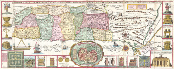
This is an extraordinary c. 1632 map of the Holy Land by the Jesuit monk Jacobus Tirinus. Oriented to the east, map depicts from Syria and Tyre southward as far as the Sinai, Egypt and Thebes. Ours survey of the map begins at the southern most point, in Egypt, where we find the city of Thebes and, slightly to the north, near Memphis, the wildly misshapen Pyramids of Egypt. Slightly further north we see the city of Tanis, made famous in Indiana Jones and the Raiders of the Lost Ark as the resting place for the Ark of the Covenant. In this spirit, slightly to the south of Tanis, the city of Ramesse is indicated as the starting point of the Biblical Exodus and the wandering of the Hebrews. We can follow their path into the desert and across the Red Sea – where Pharaoh is shown being inundated by the returning waters following Moses' parting of the Red Sea. Now in the Sinai, we can follow the footsteps of the Hebrews to Mount Sinai (Sinai Mons), where Moses is drawn throwing down the tablets of God. Slightly to the northwest of this location a cleft in the mountains reveals the location of the ancient Nabatean city of Petra. With regard to Petra, the location and gorge detail is surprisingly accurate considering that it was only 'discovered' by the Swiss adventurer Johannes L. Burckhardt, in 1812, 200 years after this map was drawn. Heading northward the lands claimed by the various tribes of Israel are beautifully detailed along with major cities, camps, roads, and trade routes. The Mediterranean is decorated with sailing ships and, in the lower left quadrant, a surveying tool between two censors. Surrounding the map proper on the left, right, and bottom margins, there are 19 maps and images of Biblical objects. The largest and most central of these is a stunning inset of Jerusalem, which notes the various temples and important buildings located there. Other images include the Arc of the Covenant, Israelite coins, Roman antiquities, views of a Menorah, various angels, and a plan of the Temple. All in all an extraordinary piece, one of the most attractive maps of the Holy Land ever made.
Originally prepared in 1632 for Jacobus Tirinus's study of the Holy LandCommentarius Vestus et Novum Testamentum Tomis Tribus Comprehensus (Commentary on the New and Old Testament). It was most likely engraved by Cornelius Galle and printed in Antwerp by Martinus Nutius. This work went through several printings in the subsequent 20 years that followed its original issue, so determining the exact issue is, for the most part, impossible. However, we can assume that this map was printed between 1632 and 1650.
Cartographer
Jacobi Tirini (1580 - 1636), who signs his work Jacobus Tirinus, was a Jesuit monk, theologian, historian, and Biblical scholar. His major work was the Commentarius in Sacram Scripturam, a two volume Bible commentary. Tirini was born in Antwerp, Belgium in 1580. Following his admission into the Jesuit Order, Tirini became a respected Biblical scholar and a prominent member of the Order. He was assigned as ”First Superior" to the Antwerp Jesuit House as well as "Directior of the Holland Mission". Tirini’s Biblical commentaries are still referenced today. More by this mapmaker...
Very good condition. Minor wear on original folds. Printed on two sheet joined at the center. Expertly done margin repair - outside printed area - to lower right margin.