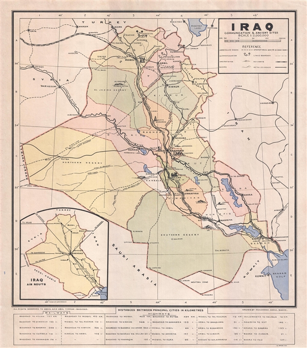
A very rare c. 1940 separately issued broadside map of Iraq. The map covers all of Iraq with an emphasis on historical sites, which are rendered in profile, commination lines, and oil pipelines. The map is undated but we have been able to narrow the date due to a number of elements. First, it shows the Mosul–Haifa Oil Pipeline, which was active only between 1935 and 1948. Second, it was printed in Cairo by the Jewish printer, Henri Moise Urwand, who was active between 1919 and 1950. Based upon this information, we have dated the map to the late 1930s or early 1940s. The map also identifies the Saudi-Iraqi neutral zone, a triangular area between the two countries, which was active from 1922 – 1981. A table at the bottom notes railway distances between towns. A second table, lists highway distances between towns. This map was drawn by Muhammad Abdul Wahid and published by Abdul Aziz Abul Timman (Baghdad). It was printed by Urwand and Sons, Cairo. All text is in English. We have identified no other records of this map in any collection public or private.
Cartographer
Henri Moise Urwand (October 25, 1879 - September 11, 1956) was a Jewish printer active in Egypt during the early 20th century. Urwand was born in Brody, now part of the Ukraine, then under the Austro-Hungarian Empire. He lived most of his life in Cairo, Egypt, where he established a printing concern. More by this mapmaker...
Very good condition. Blank on verso.