This copy is copyright protected.
Copyright © 2024 Geographicus Rare Antique Maps
1702 Stoopendaal Map of Jerusalem
Jerusalem-stoopendaal-1702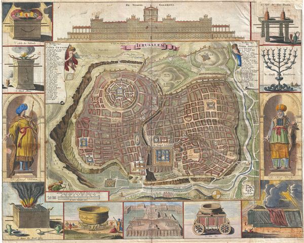

Daniel Stoopendaal (1672-1726) was a Dutch engraver and mapmaker active in Amsterdam during the early part of the17th century. Stoopendaal is best known for his garden and landscape prints. Cartographically D. Stoopendaal's most notable work is his re-engravings of Visscher maps of the Holy Land for inclusion in the Keur Bible. Daniel Stoopendaal is often confused with Bastiaan Stoopendaal, an engraver associated the Visscher firm, with whom he frequently work but was most likely not related. More by this mapmaker...
Claes Jansz Visscher (1587 - 1652) established the Visscher family publishing firm, which were prominent Dutch map publishers for nearly a century. The Visscher cartographic story beings with Claes Jansz Visscher who established the firm in Amsterdam near the offices of Pieter van den Keer and Jadocus Hondius. Many hypothesize that Visscher may have been one of Hondius's pupils and, under examination, this seems logical. The first Visscher maps appear around 1620 and include numerous individual maps as well as an atlas compiled of maps by various cartographers including Visscher himself. Upon the death of Claes, the firm fell into the hands of his son Nicholas Visscher I (1618 - 1679), who in 1677 received a privilege to publish from the States of Holland and West Friesland. The firm would in turn be passed on to his son, Nicholas Visscher II (1649 - 1702). Visscher II applied for his own privilege, receiving it in 1682. Most of the maps bearing the Visscher imprint were produced by these two men. Many Visscher maps also bear the imprint Piscator (a Latinized version of Visscher) and often feature the image of an elderly fisherman - an allusion to the family name. Upon the death of Nicholas Visscher II, the business was carried on by the widowed Elizabeth Verseyl Visscher (16?? - 1726). After her death, the firm and all of its plates was liquidated to Peter Schenk. Learn More...
Copyright © 2024 Geographicus Rare Antique Maps | Geographicus Rare Antique Maps
This copy is copyright protected.
Copyright © 2024 Geographicus Rare Antique Maps