This item has been sold, but you can get on the Waitlist to be notified if another example becomes available, or purchase a digital scan.

1849 Symonds Linen Map of Jerusalem (first scientific survey of Jerusalem)

Jeruslaem-symonds-1849
$925.00
Plan of the town and environs of Jerusalem: Copied by Permission of Field Marshal the Marquis of Anglesey, K.G. G.C.H. Master General of the Ordnance, from the original drawing of the survey made in the month of March 1841. - Main View
Processing...

1849 Symonds Linen Map of Jerusalem (first scientific survey of Jerusalem)

Jeruslaem-symonds-1849

The first scientific map of Jerusalem made during the Oriental Incident of 1840.

Title


Plan of the town and environs of Jerusalem: Copied by Permission of Field Marshal the Marquis of Anglesey, K.G. G.C.H. Master General of the Ordnance, from the original drawing of the survey made in the month of March 1841.
  1849 (dated)     28 x 29 in (71.12 x 73.66 cm)     1 : 4800

Description


This seminal 1849 map, printed on linen, is the first scientific survey of Jerusalem. Based upon survey work completed by John Frederick Anthony Symonds and Edward Aldrich, the map is centered on the walled city of Jerusalem, which is covered in considerable detail. It extends beyond the wall, illustrating topography, as far east at the Mount of Olives, west to Birket Mamillah, north as far as Kubur el Muluk (Tomb of the Kings), and south to the 'Hill of Evil Council.' Streets, roads, and important buildings are illustrated with scientific precision. The map offers several insets detailing important archeological sites, such as the El-Kalah, or the Tower of David, and the Temple Mount. At the base of the map there are cross-sections of the Old City's walls at various points.
Oriental Crises of 1840
This map was surveyed in response to the Oriental Crises of 1840. With the intention of displacing Egyptian dominance of the region under Muhammad Ali and reestablishing Ottoman hegemony, a British lead pan-European military expedition was sent to Palestine and Syria. The Royal Engineers, who accompanied the expedition, immediately began the first truly scientific surveys of the region. Led John Frederick Anthony Symonds and Edward Aldrich, the Royal Engineers arrived in Jerusalem early in 1841. According to one source, they spend about six months completing this survey.
Publication History and Census
The map was engraved by Joseph Wilson Lowry. Three editions of this map were published. The first two editions were issued in 1841 and 1846 by James Wyld. The last edition, and the present example, was issued in 1849 by John W. Parker. It subsequently provided source material for several later maps. All examples are exceedingly scarce.

CartographerS


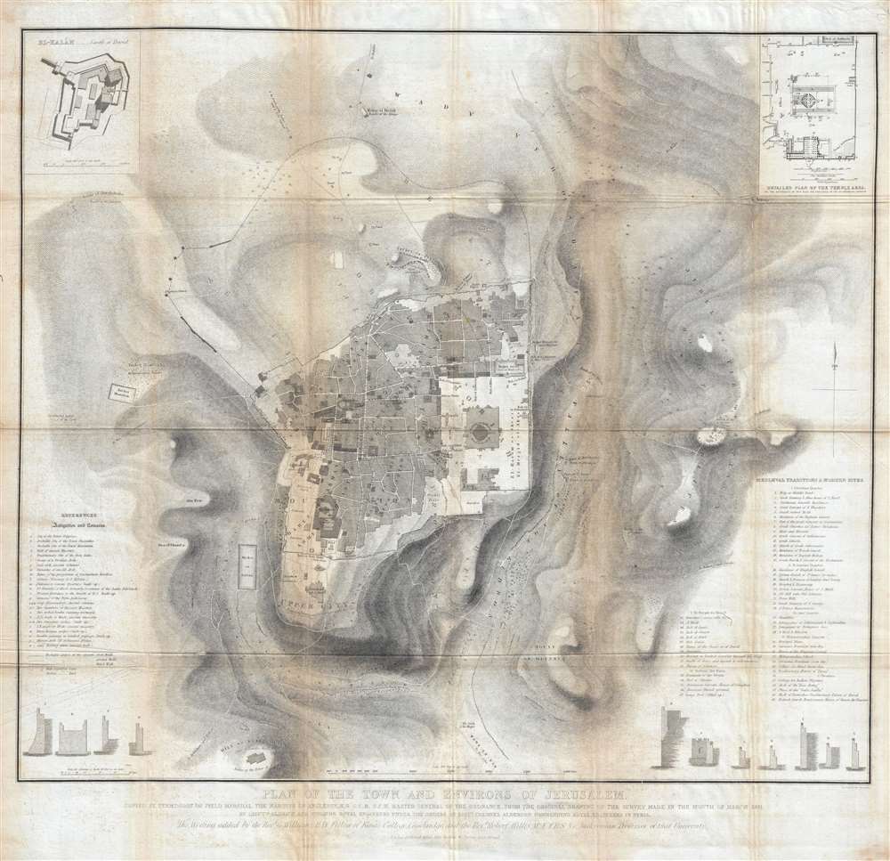
John Frederick Anthony Symonds (c. 1815 – 1852) was a British Army officer and surveyor. He was the son of Admiral Sir William Symonds, the Surveyor of the Navy. Following in his father's footsteps Symonds joined the Royal Engineers in 1833 and, by 1846, had attained the rank of Major. He was awarded the 1843 Patron's Gold Medal by the Royal Geographical Society for his revolutionary surveys in Palestine. Symonds died while serving at Argostoli, in the Greek Ionian Islands. More by this mapmaker...


Edward Aldrich (December 30, 1802 – November 23, 1857) was an English army officer, architect, and surveyor with the Royal Engineers. Aldrich was part of a detachment sent to survey Syria and Palestine in the 1840s. He was subsequently reassigned to Hong Kong where Aldrich Bay is named after him. He achieved the rank of Colonel before dying at age 57 in Marylebone, London. Learn More...


Joseph Wilson Lowry (October 7, 1803 – June 15, 1879) was an English engraver active in London during middle to later 19th century. Joseph was the son of Wilson Lowry (1760 – 1824), also an engraver under whom he apprenticed. Lowry produced numerous important maps for other publishers and even introduced his own atlas, Lowry's Table Atlas, in 1852. He was appointed engraver to the Geological Survey of Great Britain and Ireland. Learn More...

Condition


Very good. Printed on linen. Some soiling and foxing on original fold lines.

References


OCLC 234164779. Laor, E., Maps of the Holy Land: Cartobibliography of Printed Maps, 1475 - 1900, 939.