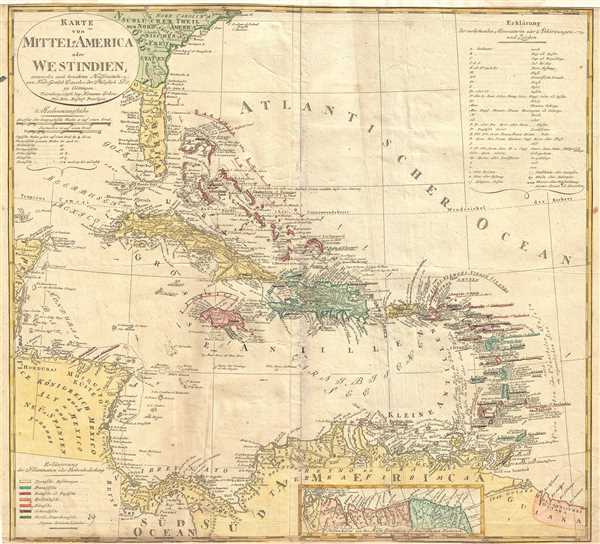
This is a beautiful 1796 map of the West Indies or Caribbean Islands by Homann Heirs. It covers the Caribbean from Florida south to Trinidad and Tobago. Includes Cuba, the Bahamas, Puerto Rico, Jamaica, Santo Domingo, and the Lesser Antilles. Based on the earlier map by Friedrich Gottlieb Canzler, the map rendered the region in detail offering both topographical and political information. British, French, Spanish, Dutch, Danish and Swedish possessions are color coded. As this region was highly important for maritime commercial and military interests, various shoals and undersea dangers are noted throughout. Presents a misshapen Florida. An inset in the lower right quadrant features Guiana.
The Spanish Main was the point of departure for enormous wealth that was shipped back to Spain in the form of gold, silver, gems, spices, hardwoods, hides and other riches; because of this, the area was ripe territory for pirates and privateers. The late 18th and early 19th century saw a resurgence of privateering as successive colonial powers jostled for supremacy in the region. Though piracy was on the rise throughout the Caribbean, nowhere was it more prevalent than in the Windward Passage, a vital maritime trade artery between Cuba and Santo Domingo. This era gave rise to the French pirates Pierre and Jean Lafitte, among the most successful pirates of all time.
A beautiful map of this important region. Issued by the Homann Heirs in 1796.
Cartographer
Homann Heirs (1730 - 1848) were a map publishing house based in Nurenburg, Germany, in the middle to late 18th century. After the great mapmaker Johann Baptist Homann's (1664 - 1724) death in 1724, management of the firm passed to his son Johann Christoph Homann (1703 - 1730). J. C. Homann, perhaps realizing that he would not long survive his father, stipulated in his will that the company would be inherited by his two head managers, Johann Georg Ebersberger (1695 - 1760) and Johann Michael Franz (1700 - 1761), and that it would publish only under the name 'Homann Heirs'. This designation, in various forms (Homannsche Heirs, Heritiers de Homann, Lat Homannianos Herod, Homannschen Erben, etc..) appears on maps from about 1731 onwards. The firm continued to publish maps in ever diminishing quantities until the death of its last owner, Christoph Franz Fembo (1781 - 1848). More by this mapmaker...
Very good. Some wear along original centerfold. Minor creasing. Overall age toning and minor foxing. Top and bottom margins extended,
OCLC: 19689723.