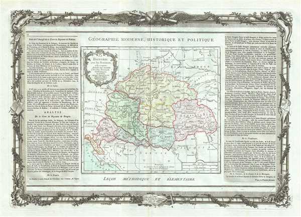
This is an attractive 1786 map of Hungary and Transylvania (modern day Romania) by French cartographer Louis Brion de la Tour. The map covers the region from the Carpathian Mountains south as far as the Danube River, including parts of modern day Hungary, Romania, Slovakia and Serbia. Renders the entire region in extraordinary detail offering both topographical and political information.
Hungary at this time was under the role of Joseph II, a dynamic leader strongly influenced by the enlightenment. Joseph shook Hungary from its malaise when he inherited the throne from his mother, Maria Theresa. In the framework of Josephinism, Joseph sought to centralize control of the empire and to rule it by decree as an enlightened despot. He refused to take the Hungarian coronation oath to avoid being constrained by Hungary's constitution. In 1781-82 Joseph issued a Patent of Toleration, followed by an edict of Tolerance which granted Protestants and Orthodox Christians full civil rights and Jews freedom of worship. He decreed that German replace Latin as the empire's official language and granted the peasants the freedom to leave their holdings, to marry, and to place their children in trades. Hungary, Slavonia, Croatia, the Military Frontier and Transylvania became a single imperial territory under one administration, called the Kingdom of Hungary or 'Lands of the Crown of St. Stephen.'
When the Hungarian nobles again refused to waive their exemption from taxation, Joseph banned imports of Hungarian manufactured goods into Austria and began a survey to prepare for imposition of a general land tax. Joseph's reforms outraged nobles and clergy of Hungary, and the peasants of country grew dissatisfied with taxes, conscription, and requisitions of supplies. Hungarians perceived Joseph's language reform as German cultural hegemony, and they reacted by insisting on the right to use their own tongue. As a result, Hungarian lesser nobles sparked a renaissance of the Hungarian language and culture, and a cult of national dance and costume flourished.
The lesser nobles questioned the loyalty of the magnates, of whom less than half were ethnic Hungarians, and even those had become French- and German-speaking courtiers. The Hungarian national reawakening subsequently triggered national revivals among the Slovak, Romanian, Serbian, and Croatian minorities within Hungary and Transylvania, who felt threatened by both German and Hungarian cultural hegemony. These national revivals later blossomed into the nationalist movements of the 19th and 20h centuries that contributed to the empire's ultimate collapse.
A beautifully engraved title cartouche adorns the top left quadrant of the map. To the left and right of the map are paste downs of French text with remarks and description of the map. Surrounding the whole is an elaborate decorative border featuring floral arrangements, surveying tools, elaborate baroque scalloping, and a winged globe. This map was issued as plate no. 35 in the most deluxe edition of Desnos’ 1786 Atlas General Methodique et Elementaire, Pour l’Etude de la Geographie et de l’Histoire Moderne.
CartographerS
Louis Brion de la Tour (1743 - 1803) was the Cartographer Royal to the King of France, his official title being Ingenieur-Geographe du Roi. Despite a prolific cartographic career and several important atlases to his name, little is actually known of his life and career. He may have been born in Bordeaux. His son of the same name was born in 1763 and published until his death in 1832. It is nearly impossible to distinguish the work of the father from the work of the son, as both used the same imprint and were active in roughly the same period. Much of their work was published in partnership Louis Charles Desnos (fl. 1750 - 1790). Their most notable work is generally regarded to be his 1766 Atlas General. More by this mapmaker...
Louis Charles Desnos (1725 - April 18, 1805) was an important 18th century instrument maker, cartographer and globe maker based in Paris, France. Desnos was born in Pont-Sainte-Maxence, Oise, France, the son of a cloth merchant. From April of 1745 he apprenticed at a metal foundry. Desnos married the widow of Nicolas Hardy, sone of the map, globe, and instrument seller Jacques Hardy. Desnos held the coveted position of Royal Globemaker to the King of Denmark, Christian VII, for which he received a stipend of 500 Livres annually. In return Desnos sent the King roughly 200 Livres worth of maps, books and atlases each year. As a publisher, Desnos produced a substantial corpus of work and is often associated with Zannoni and Louis Brion de la Tour (1756-1823). Despite or perhaps because of the sheer quantity of maps Desnos published he acquired a poor reputation among serious cartographic experts, who considered him undiscerning and unscrupulous regarding what he would and would not publish. Desnos consequently had a long history of legal battles with other Parisian cartographers and publishers of the period. It is said that he published everything set before him without regard to accuracy, veracity, or copyright law. Desnos maintained offices on Rue St. Jacques, Paris. Learn More...
Source
Desnos, Louis-Charles, Atlas General Methodique et Elementaire, Pour l’Etude de la Geographie et de l’Histoire Moderne, 1786.
The Atlas general, civil, ecclesiastique et militaire, methodique et elementaire was issued by Louis Brion de la Tour (1756-1823) and Louis Charles Desnos (1725-1805) from about 1764 with subsequent reissued until about 1790. It was intended for use by the 'young nobles of the Ecole Royale Militaire,' but also proved popular with general audiences. The atlas was compiled using an uncommon printing method involving multiple pressings as well as paste downs for each page. Typically maps from the atlas feature an elaborate rococo decorative border containing a smaller map of approximately 10 x 14 inches, a title at the top and bottom of each page, and descriptive text, generally either a pastedown or separate printing to either side of the map. This unusual combination of printings and pastedowns allowed the publisher maximum flexibility and thus it is not uncommon to find variants of this atlas both with and without the decorative borer, with and without the descriptive pastedowns, pastedowns in different languages, and with changing titles for individual maps. There are various different collations for this atlas depending upon where it was intended to be sold. For example, versions sold in the United States and England replace the large map of France with new maps of the United States. It was not uncommonly bound with de la Tour's Atlas National de France.
Very good. Minor toning along original centerfold. Minor spotting at places. Original platemark visible. Minor overall toning.