Title
La Louisiana, Parte Settentrionalle, Scoperta sotto la Protettione di Luigi XIV, Re di Francia et Descritta, e Dedicata Dal P. Cosmografo Coronelli, All'Illustriss, et Eccellentiss, S. Zaccaria Bernardi su dell Ecc. S. Francesco.
1694 (undated)
10.5 x 16.5 in (26.67 x 41.91 cm)
1 : 5069000
Description
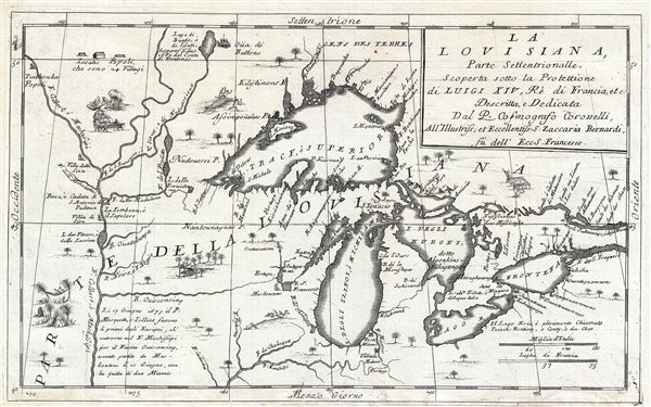
This rare 1694 production by Venetian cartographer Vincenzo Coronelli is the earliest and most important obtainable map of the Great Lakes and the headwaters of the Mississippi. Coronelli's map centers on Lake Superior, but covers all five Great Lakes and extends westward as far as the Upper Mississippi River Valley. Cartographically this map is essentially an elaboration upon the 1688 Nolin/Coronelli map, 'Partie Occidentale du Canada ou de la Nouvelle France.' Coronelli was particularly fascinated with the Great Lakes region and this map includes numerous updates and elaborations. Coronelli derived his cartographic information from the reports of Jesuit Missionaries, most of which were collected by Jean Baptiste-Louis Franquelin, who effectively acted as a cartographic clearing house of information flowing out of French America. The several explorers who influenced this map are La Salle, Hennepin, Marquette, Jolliet, Dablon, and Allouez, among others. The traces of their passage can be found throughout. Lake Ontario is named Frontenac, after the Governor of New France. On the north shore of Lake Erie the three peninsulas are clearly visible in their third time in print (two previous though more general Coronelli publications). Fort Miami, founded by La Salle, appears at the southern tip of Lake Michigan. Various portages used by explorers and fur traders are noted throughout. Coronelli identifies the R. De Chekagou roughly where Chicago is today, as well as a portage to the F. de Chekogou just to the southwest This is also the most accurate early mapping of Lake Superior, in which both Keweenaw Peninsula (P. Kioanan) and Isle Royale (I. Miniong) are located. Coronelli has decorated the map throughout with numerous wonderful vignettes depicting the day-to-lives lives of American Indians. One in particular, a crocodile eating a man, is interesting and incongruous. This map was prepared for inclusion in the second edition of Coronelli's important 1695 Atlante Veneto. In many ways this 1694 map is superior to the second most significant map of the Great Lakes, the Charlevoix/Bellin map, which appeared nearly 100 years later. It is a keystone map for any Great Lakes collection.
Cartographer
Vincenzo Maria Coronelli (August 16, 1650 - December 9, 1718) was an important 17th century cartographer and globe maker based in Venice. Coronelli was born the fifth child of a Venetian tailor. Unlikely to inherit his father's business, he instead apprenticed in Ravenna to a woodcut artist. Around 1663, Coronelli joined the Franciscan Order and in 1671, entered the Venetian convent of Saint Maria Gloriosa dei Frari. Coronelli excelled in the fields of cosmography, mathematics, and geography. Although his works include the phenomenal Atlante Veneto and Corso Geografico, Coronelli is best known for his globes. In 1678 Coronelli was commissioned to make his first major globes by Ranuccio II Farnese, Duke of Parma. Each superbly engraved globe was five feet in diameter. Louis IV of France, having heard of the magnificent Parma globes, invited Coronelli to Paris where he constructed an even more impressive pair of gigantic globes measuring over 12 feet in diameter and weighing 2 tons each. Coronelli returned to Venice and continued to published globes, maps, and atlases which were admired all over Europe for their beauty, accuracy, and detail. He had a particular fascination for the Great Lakes region and his early maps of this area were unsurpassed in accuracy for nearly 100 years after their initial publication. He is also well known for his groundbreaking publication of the first accurate map depicting the sources of the Blue Nile. At the height of his career, Coronelli founded the world's first geographical society, the Accademia Cosmografica degli Argonauti and was awarded the official title Cosmographer of the Republic of Venice. In 1699, in recognition of his extraordinary accomplishment and scholarship, Coronelli was also appointed Father General of the Franciscan Order. The great cartographer and globe maker died in Venice at the age of 68. His extraordinary globes can be seen today at the Bibliothèque Nationale François Mitterrand in Paris, Biblioteca Marciana in Venice, in the National Library of Austria and in the Globe Museum in Vienna, in the library of Stift Melk, in the Special Collections Library of Texas Tech University, as well as lesser works in Trier, Prague, London, and Washington D.C. Coronelli's work is notable for its distinctive style, which is characterized by high quality white paper, dark intense impressions, detailed renderings of topographical features in profile, and numerous cartographic innovations. More by this mapmaker...
Source
Coronelli, Vincento. Atlante Veneto, (Venice) 1695, 2nd edition.
The Atlante Veneto was a Venetian cosmographic atlas issued by the Jesuit Minorite friar, geographer, and globe maker Vincenzo Maria Coronelli. The Atlante Veneto was a massive work consisting of some 13 volumes in four parts. The first section focused on a general introduction to geography and included notes a various geographic systems and globes. The second part consisted of world maps from various periods and in various styles, including double page maps of the continents and poles derived from his earlier globe work. The third part focused on hydrography and included nautically styled maps of important rivers, bays, oceans, lakes, and gulfs. The fourth and final section detailed exploration and describing noting various explorers and their discoveries. The whole consisted of some 191 engraved charts and maps as well as an assortment of views and decorative plates. The atlas was conceived as a continuation of Blaeu's Atlas Major and in many respects follows Blaeu cartographically. Many of the other maps are derived from Coronelli's own earlier globe work and exhibit various distinctly globe-like elements. Coronelli first issued the Atlante Veneto in 1691. A second edition was prepared and issued between 1695 and 1697. Most of the individual map plates remain identical between editions. The maps of the Atlante Veneto are universally admired for their exquisite engraving and high production quality, including fine paper and premium inks. All examples were issued uncolored and have typically been left as such by dealers and collectors.
Condition
Very good condition. Minor discoloration, lower margin. Blank on verso.
References
Burden, Phillip D., The Mapping of North America: A List of Printed Maps, 1511-1670, #701. Kershaw, Keneth A., Early Printed Maps of Canada, #163. Karpinski, Louis Charles, Bibliography of the Printed Maps of Michigan, 1804-1880, p. 117. Karpinski, Louis Charles, Maps of Famous Cartographers Depicting North America, p. 55. Goss, John, The Mapping of North America: Three Centuries of Map-Making 1500-1860, 45. Tooley, R. V., The Mapping of America, 314. Phillips (Atlases) 521. McMaster University Library, Research Collections, Accession # 107030. Newbery Library, VAULT folio Ayer 135 C8 1689 pl. 91. Osher Map Library Antique Maps Collection, OL260.