This item has been sold, but you can get on the Waitlist to be notified if another example becomes available, or purchase a digital scan.

1899 Lindrooth Map of Lincoln Park, Chicago

LincolnParkChicago-lindrooth-1899
$450.00
Lincoln Park, Chicago, Ill, 1899. - Main View
Processing...

1899 Lindrooth Map of Lincoln Park, Chicago

LincolnParkChicago-lindrooth-1899

Scarce map of Lincoln Park, Chicago.

Title


Lincoln Park, Chicago, Ill, 1899.
  1899 (dated)     8 x 22 in (20.32 x 55.88 cm)     1 : 5400

Description


A fine 1899 map of Lincoln Park, Chicago, by the Chicago based surveyor and civil engineer J. H. Lindrooth. When this map was drawn, Lincoln Park had become the largest park in Chicago, offering a wide range of facilities and activities. This map is oriented with east at the top and lists some 49 sites throughout the park, ranging from monuments, to buildings, to miscellaneous courts, tunnels, bridges, and gardens. The map extends from Diversity Boulevard to Burton Place and from North Clark Street to Lake Michigan.

Cartographer


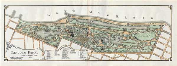
J. H. Lindrooth (September 9, 1840 - October 12, 1912) was a Chicago based civil engineer, surveyor, and draughtsman active in the late 19th and early 20th century. Lindrooth was born in Sweden before immigrating to the United States as a young man. He set up in Chicago where he was naturalized as a United States Citizen in 1872. He married Anna Elizabeth Erickson in 1869 and fathered 6 children. Lindrooth was deeply involved with the planning and construction of Lincoln Park, Chicago from about 1869 onwards. More by this mapmaker...

Source


Bryan, I. J., Report of the Commissioners and a history of Lincoln Park, (Chicago) 1899.    

Condition


Very good. Slight centerfold discoloration. Else clean.

References


Newberry Library, G 8960 .16 p. [98-99] (PrCt).