This item has been sold, but you can get on the Waitlist to be notified if another example becomes available, or purchase a digital scan.

1890 Bacon Traveler's Pocket Map of London, England

London-bacon-1890
$125.00
Bacon's New Map of London Divided into Half Mile Squares & Circles. - Main View
Processing...

1890 Bacon Traveler's Pocket Map of London, England

London-bacon-1890


Title


Bacon's New Map of London Divided into Half Mile Squares & Circles.
  1890 (undated)     25 x 33 in (63.5 x 83.82 cm)

Description


An extremely attractive c. 1890 traveler's pocket map of Victorian London, England. Covers central London on a scale of four inches to the mile - from West Kensington in the west across to the West India Docks in the east, and from Hampstead down to North Brixton and Camberwell. Offers extraordinary detail throughout noting streets, trains, ferries, docks, and important buildings. Parks are particularly well produced with superb detail on the interior. Concentric circles radiate out from Charing Cross to indicate half mile distances from the city center. Published by George Washington Bacon of 127 Strand, London.

Cartographer


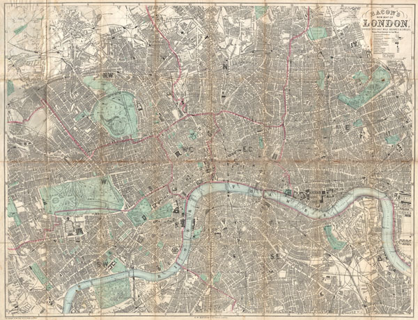
George Washington Bacon (1830 - 1922) was a London based book and map publisher active in the mid to late 19th century. Bacon's firm G.W. Bacon and Co. purchased the plates created by Edward Weller for the Weekly Dispatch Atlas then modified and updated them for several of their own important atlases, including The New Ordnance Atlas of the British Isles. In 1893, Bacon & Co. acquired the map publishing business of J. Wyld. Then, around the turn of the century, Bacon & Co. itself was folded into the Scottish publishing house of W.& A.K. Johnston. More by this mapmaker...

Source


Bacon, G. W., Bacon's New Shilling Map of London and Illustrated Guide. With a Large Scale Plan of the City, A Railway Map of the Environs. Street Directory, Cab Fares, & Co. , 1890.    

Condition


Good condition. Original folds exhibit wear, toning, and verso repair. Semi-detached from original booklet, which is included.

References


Hyde, Ralph, Printed Maps of Victorian England, 1851-1900, no. 160.