This copy is copyright protected.
Copyright © 2024 Geographicus Rare Antique Maps
1942 Geographia WWII Era Pictorial Map of London, England
London3-geographia-1942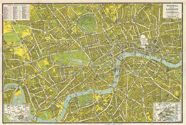

Geographia, Ltd. (1911 - 1985) was a London based cartographic publishing firm. The company was founded by Alexander Gross (1879 - 1958), a Hungarian immigrant to the United Kingdom. Geographia Ltd. is best known for its folding pocket maps and globes. Many of his maps were drawn by a mysterious 'Mr. Fountain' of which we have been able to discovery little. Gross ran into financial problems around 1940, likely associated with World War II, and relocated with offices in New York at 11 John Street. There he issued a large corpus of U.S. focused maps and city plans. By the 1940s, the branch in the United States had been renamed the Geographia Map Company and experienced rapid growth. By the 1950s Geographia had published maps of dozens of cities across the United States. In 1987, the British branch was bought out by Harper Collins and continues to produce maps under the Collins Bartholomew imprint. Rand McNally bought the New York based Geographia Map Company in the late 1980s, but its original owners repurchased the Geographia Map Company a few years later and still operate the company in Hackensack, New Jersey. Gross's daughter, Phyllis Isobella Gross / Pearsall (1906 - 1996) founded the Geographers' A-Z Map Company in London, the largest independent map publisher in the United Kingdom. In the UK, they offices were originally at 33 Strand, where they published as 'Geographia Designing and Publishing Company Ltd.'. Later, by 1933, they had relocated to 55 Fleet Street, where they remained until ate least 1937. By 1942, they related to 167 Fleet Street, followed by 114 Fleet Street by 1964. It is of note that many of the Geographia Ltd. maps feature a peculiar dating system wherein the letters in the world CUMBERLAND correspond to the numbers 1234567890, such that a date is rendered by substitution, so A.MU would break out like this A = 8, M = 3, U = 2, so 8.32 or, August 1932. Or, MM.YY e.g. E.MC = 5.31 = May 1931. More by this mapmaker...
Copyright © 2024 Geographicus Rare Antique Maps | Geographicus Rare Antique Maps
This copy is copyright protected.
Copyright © 2024 Geographicus Rare Antique Maps