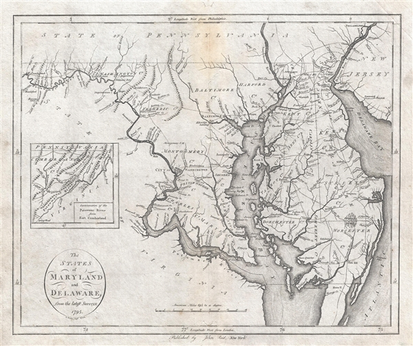
An important map of Maryland and Delaware issued by John Reid in 1796. This map is from Reid's American Atlas, only the second atlas to be published in America. The map details the Chesapeake Bay Region from Fort Cumberland on the Potomac River to the Delaware Bay and New Jersey and from Philadelphia to Watkins Point. An inset map tracks the Potomac even further west. Cartographically this map is derived form Samuel Lewis's map of 1794. It shows development at Washington D.C., roadways, and an early county structure. The present example is the second state of this map, distinguishable from the cartographically identical first state by the change of the import from 'Wayland, Reid, & Smith' to 'Published by John Reid, New York.'
Cartographer
John Reid (fl. c. 1775 - c. 1800) was an American bookseller and commercial mapmaker active in New York during the latter part of the 18th century. He is known for publishing the second American commercial atlas, the 1795 American Atlas. Unlike most American printers of his day, which were based in Philadelphia, Reid maintained his office at 106 Water Street, New York City. Little else is known of Reid's life and career. More by this mapmaker...
Source
Reid, J., An American Atlas (John Reid: New York) 1796.
An American Atlas, published by John Reid in 1796 is the second commercial atlas published in the United States. It is considered among the rarest and most interesting of all American atlases. Reid's atlas was originally issued as an accompaniment to Winterbotham's Historical, Geographical, Commercial and Philosophical View of the United States, but easily stands on its own as a production of outstanding merit. The original atlas contained 20 or 21 maps, including detailed engraved maps of North and South America, and the United States; and individual maps of New Hampshire, Maine, Massachusetts, Vermont, Rhode Island, Connecticut, New York, New Jersey, Pennsylvania, Delaware and Maryland, Virginia, Kentucky, North Carolina, South Carolina, Georgia, Tennessee, and the West Indies. The continent maps, the general map of the United States, and those of Kentucky and Washington are after maps appearing in London editions of Winterbotham; the remaining maps are unique to this work. Of the new maps, most are drawn loosely from those maps appearing in John Carey's 1795 American Atlas or, in the case of the Kentucky map, from the J. Russell's work for the 1795 London edition of Winterbotham. Most of the maps in Reid's American Atlas were engraved by Benjamin Tanner, brother to Henry S. Tanner, the most prominent map engraver in the United States. Others were engraved by David Martin, D. Anderson, John Scoles, and John Roberts. Some examples of the The American Atlas also featured the scarce Andrew Ellicott map of Washington D.C. It is noteworthy that most examples of the atlas are printed on inconsistent stock and suffer from severe condition issues due to the fact that the individual maps were printed in various different locations then shipped to Reid for binding. Reid's An American Atlas exists in only one edition and is unlikely to have been successful given the scarcity of all examples today.
Very good. Minor stain top centerfold. Minor repaired hole, centerfold located about 1 inch south of Baltimore. Verso reinforcement.
Rumsey 0845.013. Wheat, J. C. and Brun, C., Maps and Charts Published in America before 1800: A Bibliography, 519 (517). Library of Congress, Map Division, G3840 1795 .W3. Stauffer, D. M., American Engravers upon Copper and Steel, no. 106. OCLC 852833204.