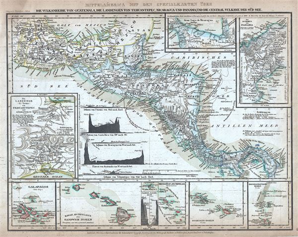
This is an attractive 1852 map of Central America by Joseph Meyer. It covers from the Yucatan and the Gulf of Mexico south as far as Panama. It includes nine insets maps. In a clockwise fashion from the top center, these detail the Great Lake of Nicaragua, The Isthmus of Panama, the Friendly Islands (Tonga), Society Islands, Marquesas Islands (Mendana), Easter Island of Waihu, the Sandwich Islands or the Hawaiian Archipelago, Galapagos Islands and the Istmo de Tehuantepec. It also includes six elevation profiles. Several notes are also included throughout.
This map was an area of considerable public interest through the 1850s. Before the construction of the Panama Canal the most practical route from the Caribbean to the Pacific was through Nicaragua. Known as the Nicaragua Route, this passage was controlled by the Accessory Transit Company, a property of the American tycoon Cornelius Vanderbilt. This vital trade artery was disrupted in 1854, two years after this map was issued, by the outbreak Civil War in Nicaragua. In an attempt to keep the route open, the Liberal Party of Nicaragua, under Francisco Castellon, enlisted the aid of the American adventurer William Walker. Walker invaded Nicaragua with some sixty armed 'colonists' and managed to have himself fraudulently elected President, after which is began an Americanization program that included reintroducing slavery into the region. Eventually Walker's small private army was defeated by the Central American Collation and Walker himself was repatriated to New York, where he faced charges for illegally waging war. Loathe to let go of his imperial ambitions, Walker again returned to the region, this time to British Honduras (Belize), where he was captured and executed by the British governors who saw him as a threat to their own economic ambitions in the construction of a trans-oceanic canal.
This map was issued in Meyer's Zeitung Atlas. Although all the maps in this atlas are not individually dated, the title page and maps were often updated while the imprint with the date was not, causing confusion to the exact date for some of the maps. Moreover some maps in the atlas were taped in at a later date as an update to the atlas. We have dated the maps in this collection to the best of our ability.
Cartographer
Joseph Meyer (May 9, 1796 - June 27, 1856) was a German industrialist and publisher, most notably for the encyclopedia Meyers Conversation-Lexicon. Born in Gotha, Germany, Meyer was educated as a merchant in Frankfurt am Main. He moved to London in 1816, but returned to Germany in a820 after his stock speculations and business adventures fell through. Once back in Germany, he began by investing in the textile trade (1820-24). Meyer began creating business plans concerning how to start railways soon after the first steam-hauled railway began operation in December 1835. He founded the Deutsche Eisenbahnschienen-Compangie auf Actien (German Railway Rail joint stock company) in 1845. Meyer also found great success as a publisher, utilizing the system of serial subscriptions to publications, a new idea for the time. He founded a company, Bibliographisches Institut in Gotha in 1825, which published several versions of the Bible, works of classical literature, atlases, the world in pictures on steel engravings, and an encyclopedia. More by this mapmaker...
Source
Meyer, J., Meyer's Zeitung Atlas, 1852.
Meyer's Zeitung Atlas, formally titled Neuster Zeitungs-Atlas Fuer Alte und Neue Erdkunde was a popular German hand-atlas published in Heidelberg by Joseph Meyer between, roughly, 1848 and 1859. The atlas is well engraved in the German style with exceptionally dense detail and minimal decoration. Meyer's Atlas, and its constituent maps, are typically very difficult to date as later editions often contain earlier maps and earlier editions later paste-in updates. That said, the atlas' frequent updates and publication run during a turbulent decade provide a noteworthy cartographic record of the period.
Very good. Minor spotting and toning at places. Minor dampstain top left margin.