This copy is copyright protected.
Copyright © 2024 Geographicus Rare Antique Maps

Details
1844 Black Map or Chart of Comparative Mountains and Rivers
1844 (undated) $350.00
1851 Black Map or Chart of Comparative Mountains and Rivers
MountainsRivers-black-1851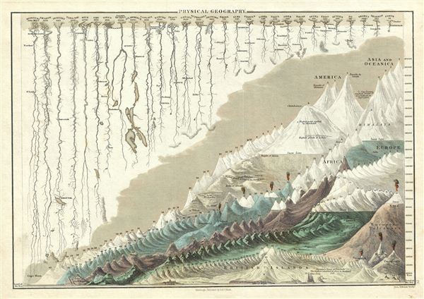

Charles and Adam Black (fl. 1807 - present) were map and book publishers based in Edinburgh. Charles and his uncle, Adam, both of Edinburgh, Scotland, founded their publishing firm in 1807. They published a series of maps and atlases throughout the 19th century. In addition to an array of atlases, the Black firm is known for their editions of the Encyclopedia Britannica (1817 - 1826) and the first publishing of Sir Walter Scott's novels in 1854. In 1889 the A. & C. Black publishing house moved to London where it remains in operation to this day. More by this mapmaker...
George Aikman (December 28, 1788 - October 16, 1865) was a Scottish printer, lithographer, and engraver active in the early 19th century. Aikman most likely apprenticed with his father of the same name, also an engraver, before joining the Edinburgh map and atlas firm of William Lizars. Several years later Aikman established himself independently as "George Aikman and Sons, Engravers and Lithographers", publishing numerous maps and prints in conjunction with the larger firm of William and Charles Black, and others. George Aikman's son, also George (1830 - 1905), became an apprentice with the firm around 1842, and eventually a journeyman engraver in Manchester and London, before returning to Edinburgh to take up a full partnership in the family business. Upon the elder Aikman's death in 1865, George became the sole proprietor of the firm and continued to publish until 1876 when he sold the business to pursue a passion for landscape painting. Learn More...
Copyright © 2024 Geographicus Rare Antique Maps | Geographicus Rare Antique Maps
This copy is copyright protected.
Copyright © 2024 Geographicus Rare Antique Maps