This copy is copyright protected.
Copyright © 2024 Geographicus Rare Antique Maps
1852 U.S. Coast Survey Map or Chart of Nantucket, Massachusetts
Nantucket3-uscs-1852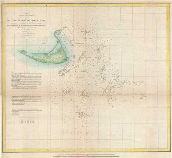

The most difficult piece of hydrography on our coast has been completed during the past season. The area of broken ground east and south of the island of Nantucket is nearly seven hundred miles in extent, and is spread with dangers, some real and some only apparent. The work which has been prosecuted there perseveringly for some seasons has made the position of the dangers fully known, and has in turn employed the resources and taxed the perseverance of some of the most able hydrographers of the survey. It was commenced in 1846 by Lieut. C. H. Davis, U.S.N., has been continues since 1849 by Lieut. C. H. McBlair, and has this year been completed by Lieut. H. S. Stellwagen. The breaking of the water over these sunken shoals and banks, which, under the name of 'Rips', occurs extensively over this region, serves, no doubt, to increase the terrors of the spot, though indicating in reality a change of depth, and not absolute shoalness. The outliers of this ground, Fishing Rip and Davis' bank, have twenty-five and a half feet upon them, while on Great Rip, the Rose and Crown, Old South, and Davis' Shoal, there are, respectively, but four, seven, six and eight feet. The arrangement of these shoals led us to suppose that there must be dangers south of Davis' Shoal, and several attempts have been made to look them up. The explorations of Lieutenant Commanding Stellwagen this year have completed the search over the space south of Davis' Shoal to deep water, without any indication of another tier of banks. The hydrography of such ground as this is truly difficult, it must be surveys with the minuteness of the harbor, without the facilities which neighboring land affords. The land cannot be seen from the deck of a vessel from Davis' shoal, and yet it must be traversed closely with the sounding line, and the position of the soundings closely determined. It is necessary to establish bases from those on land by floating objects, which, like vessels, can be seen at a sufficient distance, and to preserve temporarily the positions of these floating stations by buoys. The first severe storm not only stops the actual sounding work, but it apt to break up the system entirely by removing or changing the position of these marks. The weather fit for surveying on that peculiarly stormy part of the coast is but a small fragment of each summer, and the harbors which must necessarily be sought as a refuge on the coming up of storms, which cannot be weathered in such exposed situation are distant. It is no small source of congratulation that this difficult work is well through with, and without accident to those who have so faithfully encountered the very dangers which they seek in order to instruct others how to avoid them.The hydrography for this map was accomplished by a party under the command of Cha. H. Davis in 1846-48 and Cha. H. McBlair in 1849-51.
The Office of the Coast Survey (1807 - present) founded in 1807 by President Thomas Jefferson and Secretary of Commerce Albert Gallatin, is the oldest scientific organization in the U.S. Federal Government. Jefferson created the "Survey of the Coast," as it was then called, in response to a need for accurate navigational charts of the new nation's coasts and harbors. The spirit of the Coast Survey was defined by its first two superintendents. The first superintendent of the Coast Survey was Swiss immigrant and West Point mathematics professor Ferdinand Hassler. Under the direction of Hassler, from 1816 to 1843, the ideological and scientific foundations for the Coast Survey were established. These included using the most advanced techniques and most sophisticated equipment as well as an unstinting attention to detail. Hassler devised a labor intensive triangulation system whereby the entire coast was divided into a series of enormous triangles. These were in turn subdivided into smaller triangulation units that were then individually surveyed. Employing this exacting technique on such a massive scale had never before been attempted. Consequently, Hassler and the Coast Survey under him developed a reputation for uncompromising dedication to the principles of accuracy and excellence. Unfortunately, despite being a masterful surveyor, Hassler was abrasive and politically unpopular, twice losing congressional funding for the Coast Survey. Nonetheless, Hassler led the Coast Survey until his death in 1843, at which time Alexander Dallas Bache, a great-grandson of Benjamin Franklin, took the helm. Bache was fully dedicated to the principles established by Hassler, but proved more politically astute and successfully lobbied Congress to liberally fund the endeavor. Under the leadership of A. D. Bache, the Coast Survey completed its most important work. Moreover, during his long tenure with the Coast Survey, from 1843 to 1865, Bache was a steadfast advocate of American science and navigation and in fact founded the American Academy of Sciences. Bache was succeeded by Benjamin Pierce who ran the Survey from 1867 to 1874. Pierce was in turn succeeded by Carlile Pollock Patterson who was Superintendent from 1874 to 1881. In 1878, under Patterson's superintendence, the U.S. Coast Survey was reorganized as the U.S. Coast and Geodetic Survey (C & GS) to accommodate topographic as well as nautical surveys. Today the Coast Survey is part of the National Oceanic and Atmospheric Administration or NOAA as the National Geodetic Survey. More by this mapmaker...
Alexander Dallas Bache (July 19, 1806 - February 17, 1867) was an American physicist, scientist and surveyor. Bache is best known in cartographic circles as the Superintendent of the U.S. Coast Survey from 1843 to 1865. Born in Philadelphia, Bache, a great grandson of the statesman and inventor Benjamin Franklin, had a varied career primarily focused on education. He toured Europe on behalf of Girard College and composed an important treatise on European Education. Later he served as president of Philadelphia's Central High School and was a professor of natural history and chemistry at the University of Pennsylvania. On the death of Ferdinand Rudolph Hassler, Bache was appointed Superintendent of the United States Coast Survey. Picking up where Hassler left off Bache presided over the Survey during its most prolific period and oversaw the mapping of most of the United States coastline. To this day his name appears on countless marine pilot books and U.S. Coast Survey nautical charts. For his work he was elected Associate Fellow of the American Academy of Arts and Sciences, a Fellow of the Royal Society of Edinburgh, and a Foreign Member of the Royal Society. Following the Civil War, Bache was elected a 3rd Class Companion of the Military Order of the Loyal Legion of the United States. He died at Newport, Rhode Island and was buried in the Congressional Cemetery in Washington, DC, where he is commemorated with a monument built by American architect Henry Hobson Richardson. Learn More...
Copyright © 2024 Geographicus Rare Antique Maps | Geographicus Rare Antique Maps
This copy is copyright protected.
Copyright © 2024 Geographicus Rare Antique Maps