This item has been sold, but you can get on the Waitlist to be notified if another example becomes available, or purchase a digital scan.

1868 Shannon and Rogers Map of New York City (Manhattan)

NewYork2-shannon-1868
$225.00
Map of the City of New York. - Main View
Processing...

1868 Shannon and Rogers Map of New York City (Manhattan)

NewYork2-shannon-1868

Unusual elongated map of Manhattan Island.

Title


Map of the City of New York.
  1868 (dated)     40 x 8 in (101.6 x 20.32 cm)     1 : 23040

Description


An unusual and very rare 1868 Map of New York city by W. C. Rogers. Map covers the whole of the island of Manhattan with some detail in parts of Brooklyn, Queens and the Bronx. This unusual map offers extraordinary detail throughout with color coding according to city ward. Street names, parks, piers, and public buildings are noted. Curiously, the names and property boundaries of early landholders are overlaid on the city grid - thus offering a great deal of valuable historic information. Also offers depth soundings in the Hudson and East Rivers. In the Bronx and Queens, we can see the beginnings of both the Long Island Railroad and Metro North. Shows Central Park in detail exhibiting the fully glory of Olmsted's plan in an unusual elongated format. Prepared for inclusion in the 1868 edition of Joseph Shannon's Manual of the Common Council of the Corporation of The City of New York.

CartographerS


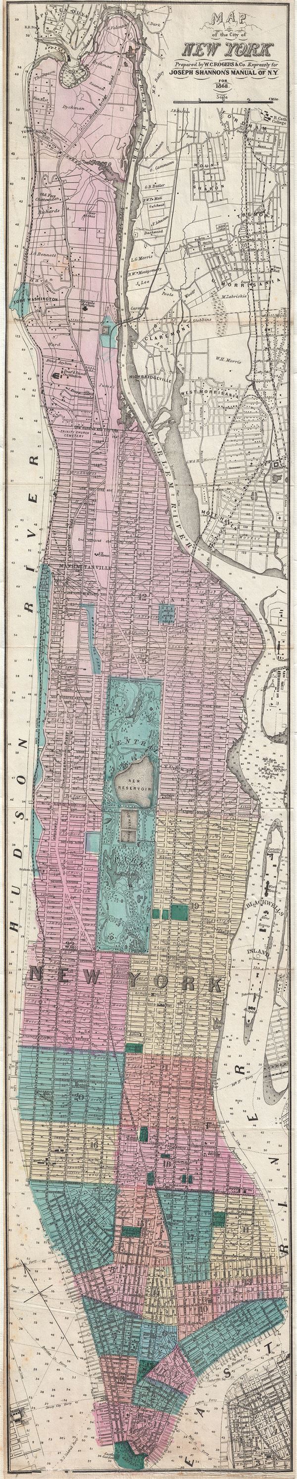
Joseph Shannon (fl. c. 1850 - 1869) produced a series of New York City almanacs and fact books entitled Manual of the Corporation of The City of New York . Shannon's Manual is very similar to the more common manual issued by Valentine. The production of this annual manual was the responsibility of the Clerk of the Common Council of the City of New York, a position held at different times by both Shannon and Valentine. The manual included facts about the City of New York, city council information, city history, and reported on the progress of public works such as Central Park. More by this mapmaker...


William C. Rogers (fl. c. 1860 - 1873) was a New York based lithographer active in the mid to late 19th century. His is best known for his engravings issued in conjunction with Joseph Shannon's Manual of the Corporation fo the City of New York. Rogers issued several maps of New York City in the 1860s and 1870s. Learn More...

Source


Shannon, J., Manual of the Common Council of the City of New York,(New York) 1868.    

Condition


Very good. Narrow margins. Backed on archival tissue for stability.

References


Phillips, Philip Lee, A List of Maps of America in the Library of Congress, page 537. Haskell, D., Manhattan Maps: A Co-operative List, 1186.