This item has been sold, but you can get on the Waitlist to be notified if another example becomes available, or purchase a digital scan.

1876 Harpers Weekly Map of New York City

NewYorkCity-harpersweekly-1876
$100.00
A Plan of the City of New York and Its Environs... - Main View
Processing...

1876 Harpers Weekly Map of New York City

NewYorkCity-harpersweekly-1876


Title


A Plan of the City of New York and Its Environs...
  1876 (dated)     15.5 x 21.5 in (39.37 x 54.61 cm)     1 :10000

Description


An uncommon 1876 map of New York City issued for Harper's Weekly. Presented surrounded by engraved illustrations of New York City buildings and monuments, this map, based on the map of John Montresor, was drawn to commemorate 100 years of New York history. The map, which was actually first issued in 1775, covers lower Manhattan as it was on even of the American Revolutionary War. Development extended roughly to today's Canal Street. The lands beyond were primarily farmland. Several early estates are noted including John Delancey's estate and N. Bayard's farm. Other estates noted include the Rutgers Estate, the Ackland Estate, G. Harrison's Brewery, the de Peyster estate, and Duyckinck's estate. A Jewish burial ground is identified near the Bowery. The Collect Pond, and its nearby tanneries is identified only as 'Fresh Water.' The proposed Common Square, where City Hall now stands, is also noted. The images surrounding the map proper illustrate important New York Landmarks, including a Methodist Church on John Street, the First Presbyterian Church on Wall Street, the Royal Exchange on Broad Street, City Hall, on Wall Street, Middle Dutch Church, Trinity Church, Walton House and St. Paul's Chapel. A larger view along the bottom of the map illustrated New York Harbor as it would have appeared in 1776. This map was engraved and issued as s Supplement to the February 19, 1876 issue of Harper's Weekly.

Cartographer


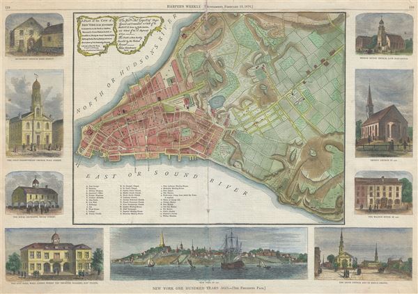
Harper and Brothers (1817 – Present) is New York based American printing publishing firm founded in 1817 by James Harper and his brother John Harper as J. and J. Harper (1817-1833). Their younger brothers Joseph Wesley Harper and Fletcher Harper joined the company around 1926 prompting the 1833 imprint change to Harper and Brothers (1833 – 1962). The firm published countless books, magazines, prints, maps, and more. They began publishing a monthly magazine, Harper's Monthly in 1850. The success of Harper's Monthly led to the introduction of a popular weekly illustrated journal, Harper's Weekly published from 1857 - 1916. They later introduced Harper's Bazar (1867) and Harper's Young People (1879). From about 1899 the business went through a series of permutations selling off some assets and developing others. The company merged with Row, Peters and Company inn 1962, rebranding itself as Harper and Row (1962 – 1990), which was acquired by Marshall Pickering in 1988. It was acquired by Rupert Mordoch (News Corp) and merged with William Collins and Sons in 1990 to form HaprerCollins (1990 – Present), the imprint under which it still publishes. Their original offices were at 331 Franklin Street, roughly below today's Manhattan Bridge. Today they have many offices and are one of the world's largest publishing companies and one of the 'Big Five' English-language publishers. More by this mapmaker...

Source


Harper's Weekly, February 19, 1876, p. 158-159.    

Condition


Average. Some centerfold damage - see image. Laid down on heavy stock. Priced accordingly.