This copy is copyright protected.
Copyright © 2024 Geographicus Rare Antique Maps
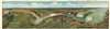
1910 Gies Pictorial Bird's Eye View / Map of the Niagara Falls
NiagaraBeltLine-gies-1910

Copyright © 2024 Geographicus Rare Antique Maps | Geographicus Rare Antique Maps
This copy is copyright protected.
Copyright © 2024 Geographicus Rare Antique Maps