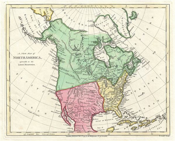
This is a scarce 1793 map of North America by Robert Wilkinson. Wilkinson's map covers the entire continent of North America from the Arctic Sea to Mexico and from the Atlantic to the Pacific. This map bears the signature of three monumental events that occurred in the fifty years previous to its publication: the conclusion of the American Revolutionary War and the founding of the United States; the successful exploration of Alaska and America's northwest coast by Captain James Cook; and the remarkable overland treks by Samuel Herne and Alexander Mackenzie to the Arctic Sea. Each of these events served to redefine the continent's geography.
The United States here appears in yello, with the original thirteen colonies noted. Cook's exploration of the Northwest Coast finally filled in one of the last blank spots on the map. Though Cook's navigations did not resolve all doubts about this region – these would be left for Perouse and Vancouver – his work was nonetheless one of many nails in the coffin of the Northwest Passage. The other great nails which would finally end all hopes of a navigable water route across North America were the overland treks of Herne and McKenzie. Both explorers made their way from lower Canada into the high Arctic, failing in the process to discover any trace of the great river ways speculated by hopeful European cartographers of the previous decade.
Wilkinson has color coded his map according to political influence. The United States is yellow, British Controlled Territories are in green and Spanish America is pink. All of the lands west of the Mississippi, with the exception of English claims in British Columbia, are accorded to Spain. Numerous American Indian nations, including the speculative Kingdom of Gold, Quivara (Quivira), are noted. Quivara, vainly sought by the conquistadores de Soto, Coronodo, and others, appears bounded by New Albion (the English name for upper California as applied by Sir Francis Drank in 1578), the Colorado River, and the speculative River of the West.
The River of the West itself excites considerable interest. Appearing on maps of the middle to late 18th century, this river, which supposedly let out into the Strait of Juan de Fuca, was believed to be a potential river passage from the interior of North America to the Pacific. Today many believe the River of the West was simply a speculative mismapping of the Columbia River. In the 18th century, however it was the great hope of the American fur traders just beginning to explore the region. Such a river, though not an effective route across the continent, would provide a highway for the vast American fur trade to offer its goods in the lucrative markets of Asia. Unfortunately, as they would discover in the subsequent 50 years, the North American fur trade did not count on the Rocky's, the Great Basin, or the High Sierras. This map was engraved by Thomas Conder and issued as plate no. 42 in the 1792 edition of Robert Wilkinson's General Atlas.
CartographerS
Robert Wilkinson (fl. c. 1758 - 1825) was a London based map and atlas publisher active in the late 18th and early 19th centuries. Most of Wilkinson's maps were derived from the earlier work of John Bowles, one of the preeminent English map publishers of the 18th century. Wilkinson's acquired the Bowles map plate library following that cartographer's death in 1779. Wilkinson updated and retooled the Bowles plates over several years until, in 1794, he issued his first fully original atlas, The General Atlas of the World. This popular atlas was profitably reissued in numerous editions until about 1825 when Wilkinson died. In the course of his nearly 45 years in the map and print trade, Wilkinson issued also published numerous independently issued large format wall, case, and folding maps. Wilkinson's core cartographic corpus includes Bowen and Kitchin's Large English Atlas (1785), Speer's West Indies (1796), Atlas Classica (1797), and the General Atlas of the World (1794, 1802, and 1809), as well as independent issue maps of New Holland (1820), and North America ( 1823). Wilkinson's offices were based at no. 58 Cornhill, London form 1792 to 1816, following which he relocated to 125 Frenchurch Street, also in London, where he remained until 1823. Following his 1825 death, Wilkinson's business and map plates were acquired by William Darton, an innovative map publisher who reissued the General Atlas with his own imprint well into the 19th century. More by this mapmaker...
Thomas Conder (1747 - June 1831) was an English map engraver and bookseller active in London during the late 17th and early 18th centuries. From his shop at 30 Bucklersbury, London, Conder produced a large corpus of maps and charts, usually in conjunction with other publishers of his day, including Wilkinson, Moore, Kitchin, and Walpole. Unfortunately few biographical facts regarding Conder's life have survived. Thomas Conder was succeeded by his son Josiah Conder who, despite being severely blinded by smallpox, followed in his father's footsteps as a bookseller and author of some renown. Learn More...
Source
Wilkinson, R., A General Atlas being A Collection of Maps of the World and Quarters the Principal Empires, Kingdoms, etc. with their several Provinces, and other Subdivisions, Correctly Delineated, (London) 1792.
Very good. Original platemark visible. Blank on verso.