Title
Carte de L'Amerique Septentrionale Pour servir a L'Histoire de la Nouvelle France.
1743 (dated)
11.25 x 14.25 in (28.575 x 36.195 cm)
1 : 27073000
Description
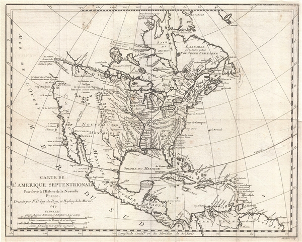
An important and influential first edition first state 1743 map of the North America by the French cartographer Jacques-Nicholas Bellin. Bellin's map covers all of North America from the Arctic to the Spanish Main, including modern day Canada, the United States, Mexico, Central America, and the West Indies. The map features several interesting annotations throughout. These include, among other interesting notes, a comment pointing out the dubious existence of Quiviara and Teguaio, mythical undiscovered cities of gold sought since the days of the Conquistadores.
By far this map's most striking feature is the broad open water route extending westward from Lake Superior, through the Lake of the Woods (Lac des Bois), and continuing via the River of the West (Fleuve de L'Ouest) through Lake Winnipeg (Ouinipigon) to the mysterious Mountain of Radiant Stones (Montagne de Pierres Brillantes). This unusual presentation of the American west is based upon Bellin's extrapolations from the explorations of French Canadian fur trader and explorer Pierre Gaultier de Varennes, Le Sieur de La Verendrye. This river system is based heavily upon a canoe map drawn for La Verendrye in 1728 by the American Indian Cree guide Auchagah. The ultimate westernmost point on this map, near the Mountain of Radiant Stones, is in fact still several thousand miles from the Pacific. Bellin's error here comes from his attempts to extrapolate from the distances, direction, and portages illustrated on Auchagah's map compounded by a lack of surveyed points west of the Lake of the Woods. The result is a double mapping of Lake Winnipeg and a vast overestimation of the distance represented. The 'Montagne de Pierres Brillantes' are an early American Indian descriptive term for the Rocky Mountains, a near impenetrable barrier located about 1200 miles further east than Bellin's map suggests.
Though not textually identified, Bellin's four spurious Islands in Lake Superior are represented. Most believe that the earliest representation of these islands occurred in Bellin's 1744 specific map of the Great Lakes. This map, though present in the same publication, actually predates the 1744 map in its construction by one year. It was Charlevoix who invented the four spurious islands in Lake Superior, known as Philippeaux, Pontchartrain, Maurepas, and St. Anne. The islands were intended to honor Charlevoix' s personal patron, the Count of Maurepas, Jean-Frederic Phelypeaux. The largest of the three islands, Philippeaux, is named directly after the count. The second largest island, Pontchartrain, refers to Phelypeaux's family estate. The third island, which may in fact be a mismapping of the factual State Islands, is named after the count's seat, Maurepas. The fourth and smallest of the islands, St. Anne, references the count's patron saint. Charlevoix described the islands as being rich in minerals leading numerous explorers to search for them in vain. Bellin dutifully introduced the four islands to his map, offered here, and such was his influence that they were subsequently copied by most subsequent cartographers, including John Mitchell in his seminal 1755 wall map of North America. The highly regarded Mitchell map was used in negotiating the 1783 Treaty of Paris that formally concluded the American Revolutionary War. Therein, the apocryphal Philippeaux was assigned as a marker for the new United States - British America border thus setting the stage, as one might image, for later political strife
Bellin's map is a profoundly French production indicative of both the sophistication of 18th century French cartography and influence of French political ideologies on mapmaking. The map centers on the Mississippi with French territory extending from the Appellation Mountains to the Rio del Nord (Rio Grande), including all of Texas and parts of modern day New Mexico - claims associated with La Salle's explorations and colonization of the Gulf Coast in 1685 (these claims, incidentally, led to 19th century U.S. Claims on Texas associated with the Louisiana's Purchase). Detailed identification of numerous American Indian nations and settlements throughout the territory, mostly along known river courses, further illustrate France's paternal and comparatively peaceable approach to New World Indian relations, commerce, and colonization. The contrast is partially noteworthy with regard to the english territories to the east of the Appellation Mountains, and the Spanish Nouveau Mexique where few American Indian settlements are noted. Just 11 years after Bellin drew this map these and other tensions would eventually devolve into the 1754-1763 French and Indian War.
Bellin prepared this map to illustrate Pierre François Xavier de Charlevoix's Histoire et description generale de la Nouvelle France, however most of its major updates are based upon the manuscripts compiled by Gaspard-Joseph Chaussegros de Lery, a French Canadian military engineer active throughout French America in the early 18th century. Charlevoix himself was a Jesuit missionary and traveler commissioned by the French Crown and the Duke of Orleans to reconnoiter French holdings in the Americas. The French had just lost control of the Hudson Bay and were actively in search of a profitable route to the Pacific, which many believed lay in the network of rivers and lakes to the west of the Great Lakes. Charlevoix thus had the secondary commission to 'inquire about the Western Sea, but [to] still give the impression of being no more than a traveler or missionary.'
Charlevoix's history and this map in particular thus proved exceptionally influential as one of the most comprehensive works on North America predating the French and Indian War. Copies of the Histoire et description generale were to be found in the libraries of many 18th century luminaries, including Voltaire, Franklin, and Jefferson. Jefferson in particular admired Charlevoix work, calling it 'a particularly useful species of reading' and no doubt influenced his decision to pursue the historic 1802 Louisiana Purchase, possibly the most significant event in the post-colonial history of North America.
Cartographer
Jacques-Nicolas Bellin (1703 - March 21, 1772) was one of the most important cartographers of the 18th century. With a career spanning some 50 years, Bellin is best understood as geographe de cabinet and transitional mapmaker spanning the gap between 18th and early-19th century cartographic styles. His long career as Hydrographer and Ingénieur Hydrographe at the French Dépôt des cartes et plans de la Marine resulted in hundreds of high quality nautical charts of practically everywhere in the world. A true child of the Enlightenment Era, Bellin's work focuses on function and accuracy tending in the process to be less decorative than the earlier 17th and 18th century cartographic work. Unlike many of his contemporaries, Bellin was always careful to cite his references and his scholarly corpus consists of over 1400 articles on geography prepared for Diderot's Encyclopedie. Bellin, despite his extraordinary success, may not have enjoyed his work, which is described as "long, unpleasant, and hard." In addition to numerous maps and charts published during his lifetime, many of Bellin's maps were updated (or not) and published posthumously. He was succeeded as Ingénieur Hydrographe by his student, also a prolific and influential cartographer, Rigobert Bonne. More by this mapmaker...
Source
Charlevoix, Pierre François Xavier de, Histoire et description generale de la Nouvelle France, avec le journal historique d'un voyage fait par ordre du roi dans l'Amérique septentrionnale, (Paris: Chez Rollin) 1744.
Condition
Very good. Remargined and backed on archival paper. Repaired tear from right margin.
References
Tooley, R. V., Map Collectors Circle, vol. 96] #692. McGuirk, D., The Last Great Cartographic Myth: Mer de L'Ouest, no. 13. Wagner, H. R., The Cartography of the Northwest Coast of America To the Year 1800, #544. Wheat, C. I., Mapping of the Transmississippi West, 1540 – 1861, #120, p. 70 - 71. Paullin and Wright, Atlas of the Historical Geography of the United States, Plate 23C.