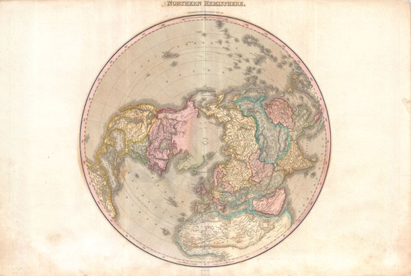
A rare and important 1818 map of the Northern Hemisphere by John Pinkerton. On a Polar projection, this map depicts North America, Asia, the East Indies, and North Africa.
In North America, thanks primarily to the work of Cook in the Pacific Northwest, the coasts are rendered with considerable accuracy. The interior of North America, particularly the American West, is still rather vague, though much of the cartography is clearly derived from the exploration of Humboldt and the Lewis and Clark expedition. Notes the apocryphal River Buenaventura as well as a conjectural placement of the western extreme of the Missouri River. The United States, still quite small, does not yet include Florida, Louisiana, California or Texas.
Asia is drawn with considerable accuracy thanks to Russian and Chinese cartographers, however, there remain some unexplored areas in Central Asia.
Africa is well mapped along the coast, but much of the interior is speculative. Shows the mythical Mountains of Kong (supposed southern boundary of the Niger River) meeting the equally mythical Mountains of the Moon (Supposed Source of the White Nile). Pinkerton positions the Mountains of the Moon much farther north than most cartographers and abandons the old Ptolemaic double lake theory. This is a curious decision that we can only assume is based upon speculation that the Mountains of the Moon are part of the same chain as the Mountains of Kong.
Far to the north, in the high Arctic, there is a partial land mass with the note 'Coast discovered by the Hunters employed by m. Liakhov.' This land refers to the Lyakhov Islands, discovered in the 1770s by Russian Fur trader Ivan Lyakhov. These islands, part of New Siberia, were said to have such an abundance of fossilized mammoth ivory that many of the smaller islands were formed from it in their entirety. Lyakhov himself brought back 10,000 tons of Ivory on his first trip and subsequent traders are said to have brought back as much as 100,000 tons in the following 20 years.
On the opposite side of the Arctic, in North America, there are notations regarding several 18th century expeditions up a number of Canadian river systems. Most of these take the form of 'Icy sea spotted by so and so.' At the time, this was the limit of Arctic exploration in Northern Canada.
Drawn by L. Herbert and engraved by Samuel Neele under the direction of John Pinkerton. The map comes from the scarce American edition of Pinkerton's Modern Atlas, published by Thomas Dobson & Co. of Philadelphia in 1818.
CartographerS
John Pinkerton (February 17, 1758 - March 10, 1826) was an Scottish writer, historian, and cartographer. Pinkerton was born in Edinburgh, Scotland. He was a studious youth with a passion for the classics. As a young man, he studied at Edinburgh University before apprenticing as a lawyer. Around this time, he began writing, with his first book, Elegy on Craigmillar Castle published in 1776. Pinkerton moved to London in 1781 to pursue his writing career in earnest. He successfully published several works of literature, poetry, and history. Pinkerton proved passionate in his literary and historical writings, but his correspondence with other cartographers has been labeled as aggressive, even insane. In addition to his work as a writer and historian, Pinkerton was one of the leading masters of the Edinburgh school of cartography which flourished from roughly 1800 to 1830. Pinkerton and his contemporaries (Thomson and Cary) redefined European cartography by abandoning typical 18th century decorative elements such as elaborate title cartouches and fantastical beasts in favor of detail and accuracy. Pinkerton's principle work is Pinkerton's Modern Atlas published from 1808 through 1815 with a special American reissue by Dobson and Co. in 1818. Pinkerton relocated to Paris in 1818, where he managed his publishing business until his death in 1826. More by this mapmaker...
Thomas Dobson (1751 - 1823) was an American publisher active in Philadelphia during the late 18th and early 19th centuries. Dobson was born in Edinburgh, Scotland in 1751 and emigrated to Philadelphia c. 1780. In Philadelphia, he established a successful printing business by republishing edited and updated versions of important British reference materials in matching quality but at a much lower price point. He is best known for publishing the first American edition of the Encyclopedia Britannica. He also published America's first Hebrew Bible. Cartographically Dobson's most notable work is 1818 republication of Pinkerton's fantastic Modern Atlas. Learn More...
Source
Pinkerton, J., A Modern Atlas, from the Lates and Best Authorities, Exhibiting the Various Divisions of the World with its chief Empires, Kingdoms, and States; in Sixty Maps, carefully reduced from the Larges and Most Authentic Sources. 1818, Philadelphia, Thomas Dobson Edition.
Very good condition. Minor discoloration along original centerfold. Minor dampstaining in lower margins. Blank on verso.
Rumsey 0732.003. Phillips (Atlases) 724. National Maritime Museum, 409.