This item has been sold, but you can get on the Waitlist to be notified if another example becomes available, or purchase a digital scan.

1755 Homann Heirs Map of New England and Eastern Canada (Nova Scotia, Quebec)

NouvelleFranceOuDuCanada-homann-1755
$450.00
Partie Orientale de la Nouvelle France ou du Canada. - Main View
Processing...

1755 Homann Heirs Map of New England and Eastern Canada (Nova Scotia, Quebec)

NouvelleFranceOuDuCanada-homann-1755

Issued on the eve of the French and Indian War or Seven Years' War.

Title


Partie Orientale de la Nouvelle France ou du Canada.
  1755 (dated)     17.5 x 22 in (44.45 x 55.88 cm)     1 : 3150000

Description


This is a beautiful 1755 map of eastern Canada and New England by Homann Heirs. Extends from Lake Ontario, St. Lawrence River and Cape Cod north to Newfoundland, Cap Rond and the Hudson Bay. The map renders the entire region in extraordinary detail offering both topographical and political information with forest and mountains beautifully rendered in profile. Rivers, lakes, shoals, soundings, missions, American Indian tribes, and early settlements are noted.

This map is an updated and revised version of the original work by the French Hydrographer Jacques-Nicolas Bellin. Centered on the St. Lawrence River, the map focuses on the French claims on the Maritime provinces of the region. Boston Harbor (Havre de Baston) and a primitively shaped Cape Cod are identified.

The map is significant on many levels, not the least of which is its presentation, from a French perspective, of the territorial alignments and claims of North America shortly prior to the outbreak of the French and Indian War. Most consider the French and Indian War to be a microcosm of the global Seven Years' War. It was however notably distinct both in that it began before that larger hostilities in Europe and that most of the major battles involved primarily parties only loosely aligned with the French or English - most specifically American Indians and lawless frontiersman, who had their own political agenda. The war began with French incursions into western Pennsylvania and other territories claimed simultaneously by French, English, and American Indian forces. Some important French forts are also identified, including Louisbourg on Isle Royale or Cape Breton Island. St. John, the capital of Newfoundland and the at the time the oldest English Colony, Port La Joye, the main French town on Prince Edward Island and the British naval base at Halifax are also identified.

A large and beautiful title cartouche in included in the lower right quadrant. Overall, this is a beautiful map of the North American theater of the Seven Years' War.

CartographerS


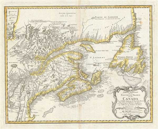
Homann Heirs (1730 - 1848) were a map publishing house based in Nurenburg, Germany, in the middle to late 18th century. After the great mapmaker Johann Baptist Homann's (1664 - 1724) death in 1724, management of the firm passed to his son Johann Christoph Homann (1703 - 1730). J. C. Homann, perhaps realizing that he would not long survive his father, stipulated in his will that the company would be inherited by his two head managers, Johann Georg Ebersberger (1695 - 1760) and Johann Michael Franz (1700 - 1761), and that it would publish only under the name 'Homann Heirs'. This designation, in various forms (Homannsche Heirs, Heritiers de Homann, Lat Homannianos Herod, Homannschen Erben, etc..) appears on maps from about 1731 onwards. The firm continued to publish maps in ever diminishing quantities until the death of its last owner, Christoph Franz Fembo (1781 - 1848). More by this mapmaker...


Jacques-Nicolas Bellin (1703 - March 21, 1772) was one of the most important cartographers of the 18th century. With a career spanning some 50 years, Bellin is best understood as geographe de cabinet and transitional mapmaker spanning the gap between 18th and early-19th century cartographic styles. His long career as Hydrographer and Ingénieur Hydrographe at the French Dépôt des cartes et plans de la Marine resulted in hundreds of high quality nautical charts of practically everywhere in the world. A true child of the Enlightenment Era, Bellin's work focuses on function and accuracy tending in the process to be less decorative than the earlier 17th and 18th century cartographic work. Unlike many of his contemporaries, Bellin was always careful to cite his references and his scholarly corpus consists of over 1400 articles on geography prepared for Diderot's Encyclopedie. Bellin, despite his extraordinary success, may not have enjoyed his work, which is described as "long, unpleasant, and hard." In addition to numerous maps and charts published during his lifetime, many of Bellin's maps were updated (or not) and published posthumously. He was succeeded as Ingénieur Hydrographe by his student, also a prolific and influential cartographer, Rigobert Bonne. Learn More...

Condition


Very good. Some wear and toning along original centerfold. Verso repair along damage on centerfold. Minor foxing. Original platemark visible.

References


OCLC: 556796781. McCorkle, B. B, New England in Early Printed Maps 1513 - 1800, 745.1.