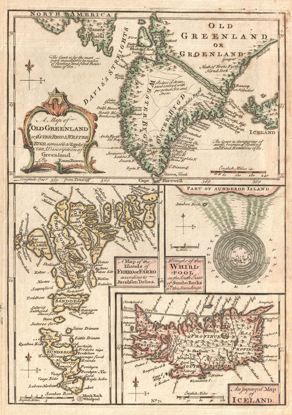
A singularly fascinating 1747 map of Greenland, Iceland and the Faroe Islands by E. Bowen. Essentially four maps on one sheet, this map of the North Atlantic islands is festooned with speculation and curiosities.
The uppermost map is based on reports by the priest Hans Egede and shows the southern portions of Greenland as well as parts of Iceland and James Island. When this map was drawn the coasts of Greenland were fairly well mapped out by Icelandic and Scandinavian whalers, but the interior was largely unknown. There was some speculation in the early 17th and 18th centuries that a water passage existed through Greenland providing easy access to Iceland from the Davis Straights. Our map notes the passage but also comments that it is now impassable due to ice. Bowen also notes that the seas on either side of the Island are treacherous due to 'mountains of Ice.'
The lower left map depicts the Faroe Islands. Today these stunning green islands are considered one of the most beautiful and unspoiled places on earth. Our map depicts the Faroe Islands according a map contained in a 17th century book on the islands written by Jacobson Debes.
The Faroe Islands have been historically treacherous for mariners due to the unpredictable currents and tides surrounding them. One of the most curious and legendary results of these currents is the great maelstrom that once roared at the southern tip of Sunderoe (today Suouroy Island) - depicted on our map at the right center. This mighty whirlpool swirled around a sheer pinnacle of rock called Monek, which was said to resemble a monk from one side and a sailing ship from the other. Reports say that the whirlpool was over a mile in diameter. Soundings show that the waters surrounding the whirlpool had a depth of some 80 to 90 fathoms, but that the waters nearer the rock, at the center of the maelstrom, were but 7 to 10 fathoms deep. Sadly this startling natural phenomenon is no more. In 1884 much of Monek Rock crumbled into the sea, creating a dangerous underwater reef and displacing the unique convergence that created the maelstrom.
In the lower right hand corner of our chart is a map of Iceland. Iceland had been fairly well mapped since the late 16th century. This map, updated from earlier maps, shows the royal residence and four primary provinces.
Drawn my Emmanuel Bowen for issue in his 1747 edition of A Complete System of Geography...
Cartographer
Emanuel Bowen (1694 - May 8, 1767) had the high distinction to be named Royal Mapmaker to both to King George II of England and Louis XV of France. Bowen was born in Talley, Carmarthen, Wales, to a distinguished but not noble family. He apprenticed to Charles Price, Merchant Taylor, from 1709. He was admitted to the Merchant Taylors Livery Company on October 3, 1716, but had been active in London from about 1714. A early as 1726 he was noted as one of the leading London engravers. Bowen is highly regarded for producing some of the largest, most detailed, most accurate and most attractive maps of his era. He is known to have worked with most British cartographic figures of the period including Herman Moll and John Owen. Among his multiple apprentices, the most notable were Thomas Kitchin, Thomas Jeffreys, and John Lodge. Another apprentice, John Oakman (1748 - 1793) who had an affair with and eventually married, Bowen's daughter. Other Bowen apprentices include Thomas Buss, John Pryer, Samuel Lyne, his son Thomas Bowen, and William Fowler. Despite achieving peer respect, renown, and royal patronage, Bowen, like many cartographers, died in poverty. Upon Emanuel Bowen's death, his cartographic work was taken over by his son, Thomas Bowen (1733 - 1790) who also died in poverty. More by this mapmaker...
Source
Bowen, E., A complete system of geography. Being a description of all the countries, islands, cities, chief towns, harbours, lakes, and rivers, mountains, mines, &c. of the known world …, 1747 edition.
Very good conditon. Mild overall toning. Old crease through southern Greenland. Blank on verso.
Rumsey 3733.070. Phillips (Atlases) 614. Phillips (Maps of America), p. 303. National Maritime Museum, p. 356.