This copy is copyright protected.
Copyright © 2024 Geographicus Rare Antique Maps
1750 Schley Map of Ormus, Persian Gulf
Ormus-schley-1750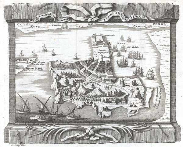

I travelled next from the land of 'Oman to the land of Hurmuz. Hurmuz is a city on the sea-coast, and is also called Mughistan. Opposite it in the sea is New Hurmuz, and between them is a sea passage of three farsakhs. We came to New Hurmuz, which is an island whose city is called Jarawn. -Ibn BatuttaThis is Schley's magnificent map of the island city of Hormuz. This strategically important Strait of Hormuz guards the entrance to the Persian Gulf. For centuries Hormuz had been an important stopping point in the shipping lanes from India to Arabia. In the course of its long history, Hormuz was, at various times, an independent state, part of the Arabia, part of Persia and subject to Portugal. Today it is part of Iran. Ormus is mentioned frequently in literature for its legendary wealth and beauty. It is named in the works of Milton, Coleridge, Mandeville, and Ibn Batutta, to name but a few.
Jacob Van der Schley (1715 - 1779) was a prominent Amsterdam engraver and draftsman based out of Amsterdam. Schley apprenticed under portrait engraver Bernard Picart, whose style he imitated. He is said to have completed several of Picart's portraits following his master's death. While Schley is primarily known for his work as a portraitist and illustrator, he also has a considerable cartographic corpus. He is known to have worked with Bellin, Hondt, and Provost, among others. More by this mapmaker...
Jacques-Nicolas Bellin (1703 - March 21, 1772) was one of the most important cartographers of the 18th century. With a career spanning some 50 years, Bellin is best understood as geographe de cabinet and transitional mapmaker spanning the gap between 18th and early-19th century cartographic styles. His long career as Hydrographer and Ingénieur Hydrographe at the French Dépôt des cartes et plans de la Marine resulted in hundreds of high quality nautical charts of practically everywhere in the world. A true child of the Enlightenment Era, Bellin's work focuses on function and accuracy tending in the process to be less decorative than the earlier 17th and 18th century cartographic work. Unlike many of his contemporaries, Bellin was always careful to cite his references and his scholarly corpus consists of over 1400 articles on geography prepared for Diderot's Encyclopedie. Bellin, despite his extraordinary success, may not have enjoyed his work, which is described as "long, unpleasant, and hard." In addition to numerous maps and charts published during his lifetime, many of Bellin's maps were updated (or not) and published posthumously. He was succeeded as Ingénieur Hydrographe by his student, also a prolific and influential cartographer, Rigobert Bonne. Learn More...
Copyright © 2024 Geographicus Rare Antique Maps | Geographicus Rare Antique Maps
This copy is copyright protected.
Copyright © 2024 Geographicus Rare Antique Maps