This copy is copyright protected.
Copyright © 2024 Geographicus Rare Antique Maps
1675 Rochefort Map of Paris, France (c. 1900 Taride issue)
Paris2-rochefort-1900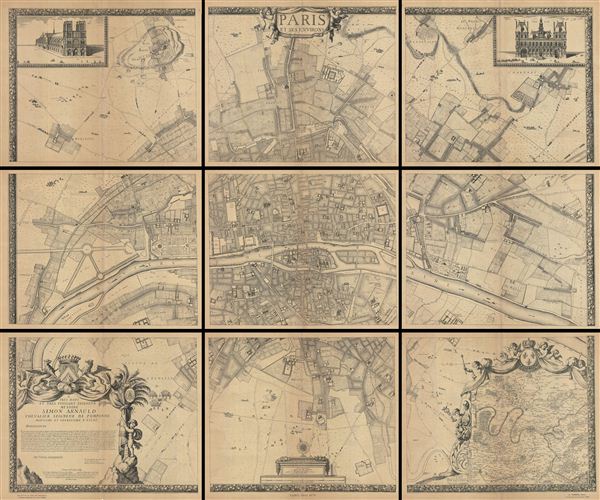

Albert Jouvin de Rochefort (c. 1640 - c. 1710) was a French cartographer and government official active during the second half of the 17th century. Rochefort is a little known figure who served as Treasure to the King of France at Limoges from 1675 to 1702. In this capacity he traveled extensively throughout France and Europe in General, publishing an account of his travels with the firm of Thierry, Louis and Claude Barbin Billain. He apparently also traveled extensively in Egypt, the Holy Land, and Turkey. He produced several important maps, most of which are on a massive scale, to illustrate his cardinal work, Le voyageur d'Europe, où sont les voyages de France, d'Italie et de Malthe, d'Espagne et de Portugal, des Pays Bas, d'Allemagne et de Pologne, d'Angleterre, de Danemark et de Suède. In 1672-5 Rochefort issued a monumental plan of Paris in nine panels, Paris et ses Environs followed by a smaller plan in 1697, Nouveau plan de Paris. Apparently a portrait of Rochefort is preserved in the National Library of France. More by this mapmaker...
Alphonse Taride (fl. c. 1850 - 1918) was a prolific Paris based publisher active in the late 19th and early 20th century. Publishing as "A. Taride", the firm produced a large corpus of work including numerous maps, tourist guides, histories, and pocket plans of different parts of France. With the advent of the automobile and improved roadways in the early 20th century, the name "Taride" became synonymous with high quality roadmaps. Taride had his offices at 18 - 20 Boulevard St. Denis, Paris. Learn More...
Copyright © 2024 Geographicus Rare Antique Maps | Geographicus Rare Antique Maps
This copy is copyright protected.
Copyright © 2024 Geographicus Rare Antique Maps