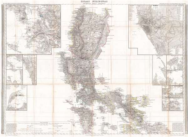
A stunning 1849 Francisco Coello map of the Philippine Islands. This map is considered the first scientific topographical map of the Philippines and the most important map of the Philippines to appear in the 19th century. Of the three maps Coello prepared of the Philippines, this is the most important, covering the archipelago from northern Luzon to southern Mindoro, covering all of Luzon and Mindoro, as well as parts of Isla Han Smaar, Masbate and numerous smaller islands. In additional to the main map, there are 11 insets, including detailed maps of the City of Manila, Manila Bay, and Cavite and Bacoor Bay, among others.
This map is the culmination of nearly a century of Spanish survey work in the Philippines. Coello, and his partner, the geographer Antonio Morata, carefully assembled the various surveys, into this, a composite map of the region based exclusively on scientific survey work. The completed map was unprecedented it size and detail and the foundation for all subsequent mapping of the region until the end of the19th century. It was used in treaty negotiations by both sides for both the Spanish-American War (1898) and the Philippine-American War (1899-1902). In addition, it provides the essential cartographic data for several important subsequent maps, inlcluidng Anselmo Ollero’s Carta Itineraria de la Isla de Luzon (1882) and Ramon Prats’ Islas Filipinas (1887).
This map was issued as part of Coello's opus, the Atlas de España y sus posesiones de Ultramar. The atlas, conceived jointly by Coello and Morata and issued in parts from about 1848 onwards, was a wildly ambitions project consisting of large format separately issued maps of all parts of Spain and her few remaining overseas possessions. Due to Coello's death and the disruption of the Spanish American War, the Atlas was never completed. Nonetheless, by the time of Coello's death in 1898, some 46 parts were published. This map of the Philippines is one of the first maps Coello issued for the atlas, appearing, in 1849, just one year into the production of the ambitious Atlas de España.
Cartographer
Francisco Coello de Portugal y Quesada (1822 - September 30, 1898) was a Spanish cartographer, explorer, and military engineer active in the mid-19th century. Coello was born in Jaen, Spain and joined the military in 1833, enrolling at the Special Army Corps of Engineers Academy of Guadalajara. Upon graduating with honors he joined Corps of Military Engineers where after serving in the First Carlist War, and later in Algeria, he attained the rank of Colonel. Coello later founded the Geographical Society of Madrid and served many years as its president. He was also a corresponding member of the American Geographical Society and a full member of the Real Sociedad Geográfica de España. Coello's greatest work, his monumental Atlas de España y sus posesiones de Ultramar, was truncated by his death in 1898 and consequently never completed. Nevertheless, the work is of historical significance as the first scientifically produced maps of Spain, Cuba, and Porto Rico. More by this mapmaker...
Source
Coello, F., Atlas de España y sus posesiones de Ultramar, (Madrid) 1849.
Very good. Backed on archival tissue. Some wear and toning along original fold lines.
OCLC 920563951. Phillips (Atlases) #3137. Quirino, Carlos, Philippine Cartography, pp.177-8. PHIMCOS/Metropolitan Museum of Manila, Three Centuries of Philippine Cartography (exhibition catalog), pp.56-7.