Title
The New York Herald: The Seat of War in Virginia. Positions of the Rebel Forces, Batteries, Intrenchments and Encampments in Virginia - the fortifications for the protection of Richmond.
1861 (dated)
21 x 14 in (53.34 x 35.56 cm)
1 : 800000
Description
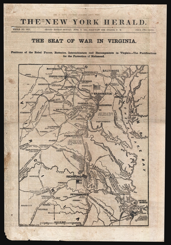
A rare 1861 Civil War Era newspaper with front page woodcut map illustrating the theater of war in the vicinity of Washington D.C., Fredericksburg, Virginia, and Richmond, Virginia. This map was issued in the June 17, 1861 second daily edition of the New York Herald. It covers from Baltimore, Maryland, to Norfolk, Virginia, and from Staunton to the Chesapeake Bay. This map depicts strategic cities and towns, transportation routes, fortified positions, and the location and number of Confederate troops at several locations. The map noted, for example, that there were '15,000 troops at Manassas Junction and 15,000 more on the Manassas Gap Railroad' nearby Washington and Richmond are heighted as capitals of their respective nations with their flags displayed. It is of note that this map was issued three days before Virginia officially joined the Confederacy on June 19, and thus, before Richmond was made the capital. The Confederate flag shown near Richmond is the 'Stars and Bars' model used from March 4, 1861 – May 21, 1861, so is here 27 days out of date. Within a month Union forces would suffer a disastrous defeat at the First Battle of Bull Run (First Battle of Manassas, proving that the war would not be one with a single battle and would indeed turn out to be a long drawn out affair.
The map is part of the newspaper's full issue, printed on a single broadsheet and folded in quarto. Textual content related to the Civil War includes 'The Rebellion,' 'State of Affairs at the Seat of War,' 'Retreat of the Rebels from Manassas Junction Towards Richmond,' 'Skirmish Between the District of Columbia Volunteers and the Rebels at Leesburg,' 'Movements of the troops Near Washington,' 'Interesting from Fortress Monroe,' 'Gen. Butler's Position to be Advanced Several Miles up the Peninsula,' 'Affairs at the Seat of War in the West,' and more.
This is the rare second edition of the New York Herald, published with updated information as of 1:30 PM, June 17, 1861. Note, this is not a later reissue or the digest version of the newspaper, it ithe original daily as distributed on the streets of New York during the course of the American Civil War. Not in Bosse. This map was engraved for the New York Herald by Waters and Son, Engravers based in New York City.
Source
New York Herald, morning edition, June 17, 1861.
Condition
Good. Old newsprint. Even toning. Some soiling. Large newspaper quarto. Uncut. Large old tear to back of newspaper not affecting map, reparied with stitching.
References
Library of Congress Civil War Maps (2nd ed.), 451.3. Library of Congress, Map Division, G3881.S5 1861 .N4.