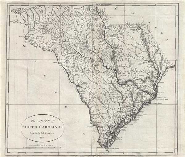
A fine example of John Reid's scarce and important 1796 map of South Carolina. This is the second folio map of a U.S. state to appear in an American commercial atlas. The map covers roughly the territory of modern day South Carolina, running along the Atlantic coast from Long Bay to the Savannah Sound, and then inland with the Savannah and Tugeloo River's forming the southern boundary of the state. The norther boundary runs just north of the 35th parallel, as today, before angling southward at the Catawba River and angling east again between the 34th and 35th parallels, finally meeting the coast just west of the Cape Fear River. The northwest boundary with Georgia is further complicated as the north branch of the Tugaloo River, the Chattooga, is confused with the Tallulah River. This forces the border of the state far to the west. In addition, there is an error in scale contributing to the state appearing about 15% larger than actuality.
Even so, Reid's map one of the finest maps of South Carolina of its period and offers considerable detail throughout, especially along the various river systems. It names the eight precincts of the state as well as municipal boundaries, cities, towns, roads, and topographical notes. American Indian villages in particular are noted in the western part of the state and identified by little teepees rather than oval and cross patter reserved for European settlements.
This map was engraved by Benjamin Tanner and is based upon the 1795 John Carey / Samuel Lewis map of the same region It was issued to accompany Reid's An American Atlas. The atlas was intended to supplement the American edition of Winterbotham's Historical, Geographical, Commercial and Philosophical View of the United States.
CartographerS
John Reid (fl. c. 1775 - c. 1800) was an American bookseller and commercial mapmaker active in New York during the latter part of the 18th century. He is known for publishing the second American commercial atlas, the 1795 American Atlas. Unlike most American printers of his day, which were based in Philadelphia, Reid maintained his office at 106 Water Street, New York City. Little else is known of Reid's life and career. More by this mapmaker...
Benjamin Tanner (March 27, 1775 - c. 1846) was an American engraver active in the late 18th and early 19th centuries. Benjamin was the brother of the more prominent younger brother, the Philadelphia engraver Henry S. Tanner. Benjamin, who was based in New York City for most of his early career. Although is master is unknown, he most likely trained under the New York mapmaker Peter R. Maverick. His earliest work dates to 1792 and his is known to have engraved many of the maps for Reid's 1775 An American Atlas. Around 1811 he relocated to Philadelphia and established a business with his brother as a general engraver and map publisher. He also worked as a bank note publisher under the imprint of Tanner, Vallance, Kearny & Co. perfecting the stereographic technique until roughly 1846. Learn More...
Source
Reid, J., An American Atlas (John Reid: New York) 1796.
An American Atlas, published by John Reid in 1796 is the second commercial atlas published in the United States. It is considered among the rarest and most interesting of all American atlases. Reid's atlas was originally issued as an accompaniment to Winterbotham's Historical, Geographical, Commercial and Philosophical View of the United States, but easily stands on its own as a production of outstanding merit. The original atlas contained 20 or 21 maps, including detailed engraved maps of North and South America, and the United States; and individual maps of New Hampshire, Maine, Massachusetts, Vermont, Rhode Island, Connecticut, New York, New Jersey, Pennsylvania, Delaware and Maryland, Virginia, Kentucky, North Carolina, South Carolina, Georgia, Tennessee, and the West Indies. The continent maps, the general map of the United States, and those of Kentucky and Washington are after maps appearing in London editions of Winterbotham; the remaining maps are unique to this work. Of the new maps, most are drawn loosely from those maps appearing in John Carey's 1795 American Atlas or, in the case of the Kentucky map, from the J. Russell's work for the 1795 London edition of Winterbotham. Most of the maps in Reid's American Atlas were engraved by Benjamin Tanner, brother to Henry S. Tanner, the most prominent map engraver in the United States. Others were engraved by David Martin, D. Anderson, John Scoles, and John Roberts. Some examples of the The American Atlas also featured the scarce Andrew Ellicott map of Washington D.C. It is noteworthy that most examples of the atlas are printed on inconsistent stock and suffer from severe condition issues due to the fact that the individual maps were printed in various different locations then shipped to Reid for binding. Reid's An American Atlas exists in only one edition and is unlikely to have been successful given the scarcity of all examples today.
Very good. Minor verso reinforcement. Else clean. Original platemark visible.
Wheat, J. C. and Brun, C., Maps and Charts Published in America before 1800: A Bibliography, 605. Rumsey 0845.017.