1727 Van der Aa Map of Sumatra, Singapore, and Malaya

SumatraSingaporeMalaya2-vanderaa-1727
$650.00
L'Ile de Sumatra suivant les plus nouvelles observations des meilleurs geographes. - Main View
Processing...

1727 Van der Aa Map of Sumatra, Singapore, and Malaya

SumatraSingaporeMalaya2-vanderaa-1727

Rare Singapore Map! Only 100 known to have been printed.
$650.00

Title


L'Ile de Sumatra suivant les plus nouvelles observations des meilleurs geographes.
  1727 (undated)     10.5 x 6.5 in (26.67 x 16.51 cm)     1 : 7500000

Description


An exceptional and scarce 1727 Pieter van der Aa map of Sumatra, the Strait of Malacca, Singapore, and the southern part of the Malaya Peninsula. Taking full advantage of the small paper size, this map is oriented to the northwest with Sumatra presented vertically. The map locates the important VOC trade centers in both Sumatra and Malaysia, including Atchem (Aceh), Palimbam (Palembang), Malacca and Ihor (Johore). Singapore itself is not identified but the Strait of Singapore is named and the island that would later become Singapore is rendered. An unusual decorative cartouche appears in the upper left quadrant. This map was issued for Van der Aa's scarce La Galerie agreable du Monde. Only 100 are known to have been printed, and so, while none know how many have survived, this map may be considered exceedingly scarce.

Cartographer


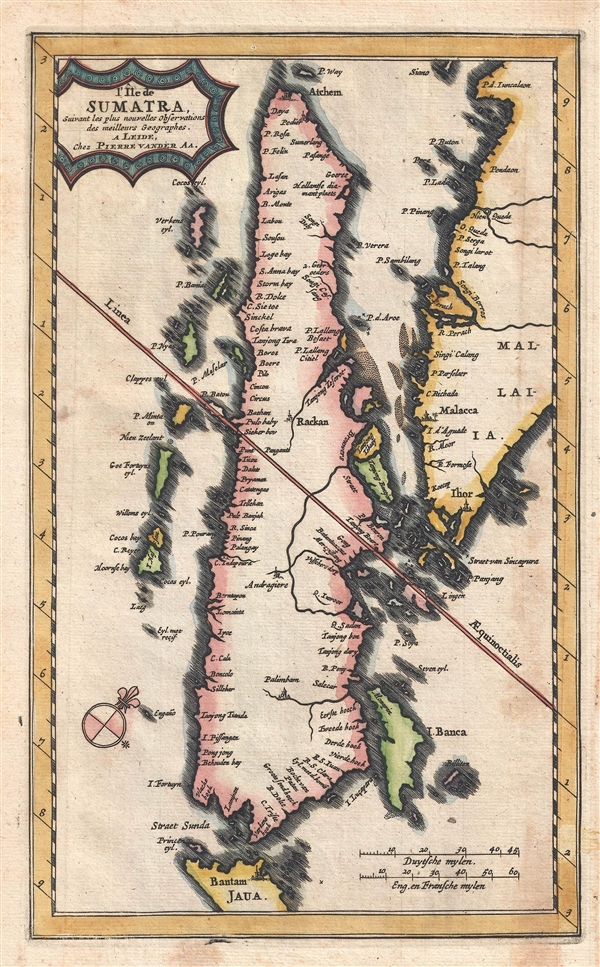
Pieter van der Aa (1659 - 1733) was a Dutch publisher of maps and atlases active in the late 17th and early 18th centuries. Van der Aa was born in Leyden in 1659. At nine he was apprenticed to a local bookseller and, by 21, had established his own publishing, printing, and auctioneering house. In 1692 Van der Aa was appointed to be one of the High Commissioners of the Booksellers Guild. During his long and impressive career Van der Aa produced thousands of maps, including a vast 28 volume atlas containing no less than 3,000 maps. Few of Van der Aa's maps were original productions, most being copied from the work of earlier cartographers. Nonetheless, when one of Van der Aa's rare original pieces does appear, his style, with unusual projections, elegant engraving, and precise detail, is instantly recognizable and highly desirable. He also pioneered the cartographic idea of separating border artwork from the map plate itself such that every map in a collection could have a similar elaborate border without actually having to re-engrave the complex plates. This technique was used to great effect by later 18th century publishers like Brion de la Tour. Following Van der Aa's death in 1733, his much admired Nouvel Atlas was reissued by the Dutch firm of Covens & Mortier. Today Van der Aa's work is admired for its fine delicate engraving and unusual projections and is considered highly desirable among collectors. More by this mapmaker...

Source


Aa, Van der, La Galerie agreable du Monde, (Leiden) 1727.     La Galerie agreable du Monde was monumental 66 part atlas published by Pieter van der Aa in Leiden from 1724 to 1729. It remains, to this day, the largest atlas ever published and possibly the costliest and comprehensive geographical work ever produced. The volume contained reissues of maps by Blaeu, Visscher, de Wit, Meurs, Halma, Mortier, Allard, in addition to Van der Aa's own maps prepared specifically for this atlas. Only 100 copies are known to have been produced, how many have survived is unknown, but this means that all of the unique maps from this important work are exceedingly scarce. It contained not only maps, but also illustrations and other engraving totaling over 4000 images.

Condition


Very good condition. Blank on verso. Original platemark visible.

References


OCLC 690290685.