1726 Valentijn Map of East Java, Indonesia

TVorstendomBalamboang-valentijn-1726
$450.00
S. Sevende bestek 'T Vorstendom of Landschap Balamboang. - Main View
Processing...

1726 Valentijn Map of East Java, Indonesia

TVorstendomBalamboang-valentijn-1726

$450.00

Title


S. Sevende bestek 'T Vorstendom of Landschap Balamboang.
  1726 (undated)     18.5 x 11 in (46.99 x 27.94 cm)     1 : 500000

Description


This is a rare and exquisite 1726 map of eastern Java by Francois Valentijn. It covers the eastern tip of Java as well as the western portions of Bali including the modern day Bondowosa Regency, Situbondo Regency, Jember Regency and the Banyuwangi Regency including Blambangan Peninsula and the Bali Strait. The map offers beautiful engraving and extraordinary detail throughout, noting rice plantations, mountain ranges, forests, rivers and a host of additional topographical features. The previously unknown southern shore is mapped both correctly and in considerable detail. Offshore reefs, soundings and coastal features are also shown.

The Dutch were active in this region since the 17th century and had no doubt produced accurate manuscript charts of the Island, but these were carefully guarded trade secrets controlled by the powerful Vereenigde Oostindische Compagnie (V.O.C. or Dutch East India Company). The VOC's policy of extreme secrecy, especially regarding cartographic matters, historically limited publication of their charts. As a VOC officer, Valentijn doubtless had access to VOC manuscript records which he complied into his remarkable collection of maps. Valentijn's maps are so superior to previous maps that their publication itself is rather surprising, making this particular map an extremely rare find. A highly important map of the region and a must for a serious collection focusing on the East Indies. Prepared by Francois Valentijn for inclusion in his eight volume five part masterwork Oud en Nieuw Oost-Indien.

Cartographer


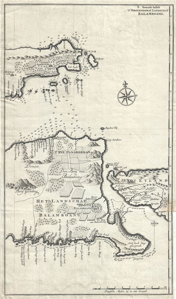
Francois Valentijn (April 17, 1666 - August 6, 1727) was a Dutch minister, naturalist, colonial administrator, and historian active in Holland and the East Indies, in the late 17th and early 18th centuries. Valentijn was born in Dordrecht, Holland and studied at the Universities and Leiden and Utrecht before, in 1685, taking a position with the Dutch East India Company (VOC). He remained in the East Indies for about 10 years before returning to Dordrecht. Unable to adjust to life in Europe, he returned to the East Indies in 1705 where he remained for another 9 years. After 19 total years in the Orient working for the VOC, Valentijn once again returned to Holland where he composed his eight volume five part masterwork Oud en Nieuw Oost-Indien. The scope and detail of this work, including over 1000 engraved images and numerous maps was unprecedented with regards to Asia. The work contained some of the finest and most detailed large scale maps of the East Indies ever published. The most important of these focus on Taiwan and Malaya. Valentijn most likely drew on secret VOC manuscript maps and documents, a fact that makes it exceptionally surprising that his works were actually published. Valentijn academic scholarship, in sharp contrast to his cartographic work, is often highly criticized as being self-aggrandizing and, more often than not, plagiarized. More by this mapmaker...

Source


Valentijn, F., Oud en Nieuw Oost-Indien,( Dordrecht: J. van Braam) 1726.    

Condition


Very good. Minor wear along original fold lines. Minor wear and verso repair near right bottom margin. Narrow bottom right margin. Original platemark visible.