This copy is copyright protected.
Copyright © 2024 Geographicus Rare Antique Maps
1943 F. E. Manning World War II Propaganda Map of the World: Target Berlin
TargetBerlin-manning-1943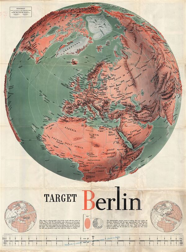

This map is a photographic view of the world with the center at Berlin. Thus with the detachable scale distances can be measured along any line running thru Berlin. It should be noted that an inch at the center represents less mileage than an inch closer to the edges. The detachable scale has been designed to compensate for this and should be used only with the center on Berlin. The photographic process used in making this map makes all distances measured with the tape approximate only. Distances are shown in statute miles. Lines between key cities do not represent regular air routes in all cases. They show distances between points that do not fall on a line going thru the center of the projection.
The verso features a segmented breakdown of the most recent war news on various fronts. Most of it is quite good for the Allies. Following a series of Allied victories in Italy, Russia, at Stalingrad, in East Asia, and Indonesia, the War had, by this date, turned firmly against the Axis powers. As such, there was little need for 'sugar coating' and the general message was, in as much as war can be, truthfully positive.
This is one of many 'Newsmaps' published weekly by the Army Orientation Course of the Special Service Division Army Service Forces, a propaganda arm of the United States War Department. The Newsmaps typically employed bold typesetting and dramatic imagery to relay the most recent war news from a distinctly 'positive' perspective. Few Newsmaps were as dramatic or impactful as Manning's 'Target Berlin,' although one, a very similar map, also by Manning and issued later in the year, 'Target Tokyo' is an exception. Both are in a style similar to that of Richard Edes Harrison, a pioneer in journalistic cartography.
F. E. Manning (fl. c. 1940 - 1945) was an American journalistic cartography employed with the Chicago Sun. During World War II he produced numerous propagandistic maps for the Army Orientation Course of the Special Service Division Army Service Forces, a division of the United State War Department. Our research has, unfortunately, been able to unearth significant details regarding his personal life or his career at the Chicago Sun. More by this mapmaker...
Copyright © 2024 Geographicus Rare Antique Maps | Geographicus Rare Antique Maps
This copy is copyright protected.
Copyright © 2024 Geographicus Rare Antique Maps