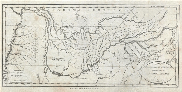
A fine example of one of the second earliest obtainable map of Tennessee, issued 1796, the first year of Tennessee's statehood. This is the rare first state of John Reid's 1796 Map of the Tennassee Government. Cartographically derived from General Daniel Smith's map of 1794, this map covers from the Mississippi River to The Catawba River and from Fort Massae to the Coosa River. The map details American Indian villages, towns, roads, trails, and settlements, among them Nashville, Clerksville, and Knoxville. A key in the lower left provides symbols for public roads, Indian boundaries, Indian towns, and 'Wedth of Rivers in Yards.' Of particular interest are boundary and survey lines relating to the original documents incorporating Tennessee Territory.
The entirety of Tennessee was originally included in North Carolina's coast to coast charter which – for practical political purposes was generally assumed to terminate at the Mississippi River. Tennessee's easternmost counties were thus originally the western most counties of North Carolina. In the years following the American Revolutionary War the government of North Carolina was too depleted to defend its westernmost settlements against American Indian attacks or support their right to navigate the Mississippi River. Tennesseans realized they would have to look to themselves for military support. In 1784 Tennessee's eastern counties rallied and attempted to form the new state of Franklin with John Sevier as governor. Meanwhile, in western Tennessee, the Cumberland Settlements ratified the Cumberland Compact and even brokered a treaty with Spain. Despite bold aims, both the Cumberland Compact and attempts to promote the state of Franklin lacked federal support and were suppressed by North Carolina. This changed in 1789 when North Carolina ratified the constitution and joined the Union. In doing so it gave up the rights to its western land paving the way for Tennessee to peruse statehood in 1795-6.
This is the first edition of Reid's Map of the Tennassee Government. It is identifiable as such by the imprint, 'J. Reid, J. L. Wayland & C. Smith' which appears just below the bottom border. In subsequent editions only J. Reid, or nothing at all, is printed in at this location. The present map was engraved by Benjamin Tanner of New York. This map was published in John Reid's 1796 American Atlas, the second commercial atlas to be printed in the Untied States. Although Reid's atlas is derived from the work of of London cartographer John Russell, this and 14 other maps from the atlas focusing on American states and regions, are new engravings that first appeared in this atlas.
CartographerS
John Reid (fl. c. 1775 - c. 1800) was an American bookseller and commercial mapmaker active in New York during the latter part of the 18th century. He is known for publishing the second American commercial atlas, the 1795 American Atlas. Unlike most American printers of his day, which were based in Philadelphia, Reid maintained his office at 106 Water Street, New York City. Little else is known of Reid's life and career. More by this mapmaker...
Benjamin Tanner (March 27, 1775 - c. 1846) was an American engraver active in the late 18th and early 19th centuries. Benjamin was the brother of the more prominent younger brother, the Philadelphia engraver Henry S. Tanner. Benjamin, who was based in New York City for most of his early career. Although is master is unknown, he most likely trained under the New York mapmaker Peter R. Maverick. His earliest work dates to 1792 and his is known to have engraved many of the maps for Reid's 1775 An American Atlas. Around 1811 he relocated to Philadelphia and established a business with his brother as a general engraver and map publisher. He also worked as a bank note publisher under the imprint of Tanner, Vallance, Kearny & Co. perfecting the stereographic technique until roughly 1846. Learn More...
Source
Reid, J., An American Atlas (John Reid: New York) 1796.
An American Atlas, published by John Reid in 1796 is the second commercial atlas published in the United States. It is considered among the rarest and most interesting of all American atlases. Reid's atlas was originally issued as an accompaniment to Winterbotham's Historical, Geographical, Commercial and Philosophical View of the United States, but easily stands on its own as a production of outstanding merit. The original atlas contained 20 or 21 maps, including detailed engraved maps of North and South America, and the United States; and individual maps of New Hampshire, Maine, Massachusetts, Vermont, Rhode Island, Connecticut, New York, New Jersey, Pennsylvania, Delaware and Maryland, Virginia, Kentucky, North Carolina, South Carolina, Georgia, Tennessee, and the West Indies. The continent maps, the general map of the United States, and those of Kentucky and Washington are after maps appearing in London editions of Winterbotham; the remaining maps are unique to this work. Of the new maps, most are drawn loosely from those maps appearing in John Carey's 1795 American Atlas or, in the case of the Kentucky map, from the J. Russell's work for the 1795 London edition of Winterbotham. Most of the maps in Reid's American Atlas were engraved by Benjamin Tanner, brother to Henry S. Tanner, the most prominent map engraver in the United States. Others were engraved by David Martin, D. Anderson, John Scoles, and John Roberts. Some examples of the The American Atlas also featured the scarce Andrew Ellicott map of Washington D.C. It is noteworthy that most examples of the atlas are printed on inconsistent stock and suffer from severe condition issues due to the fact that the individual maps were printed in various different locations then shipped to Reid for binding. Reid's An American Atlas exists in only one edition and is unlikely to have been successful given the scarcity of all examples today.
Very good. Minor soiling. Blank on verso.
Wheat, J. C. and Brun, C., Maps and Charts Published in America before 1800: A Bibliography, 654. Phillips (Atlases) 1366. Rumsey 0845.019.